Louisiana Mississippi Tennessee Severe Storm Line Pushes From Gulf Coast Toward Memphis With 70+ MPH Winds Hail and Possible Tornado Spin-Ups Overnight
UNITED STATES — A powerful line of severe thunderstorms is pushing north across the Gulf Coast and Mississippi Valley, stretching from southern Louisiana through Mississippi and toward Memphis, Tennessee, bringing the risk of damaging winds, hail, and possible tornado spin-ups overnight.
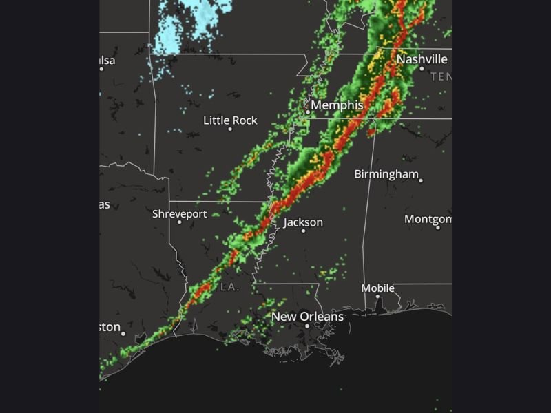
Radar imagery shows a well-organized line of storms, often referred to by meteorologists as a squall line, moving northeast through the region. The system is already producing intense thunderstorms capable of dangerous weather conditions across several states. Meteorologists say this storm line is built to produce widespread impacts as it moves deeper into the Mississippi Valley overnight.
Large Storm Line Stretching Across Multiple States
Weather radar shows the storm system forming a long, nearly continuous line of severe thunderstorms extending from the Gulf Coast northward through the Mississippi River Valley.
Major areas along the path include:
- Southern Louisiana
- Central and northern Mississippi
- Western Tennessee including Memphis
Cities such as Jackson, Mississippi, Memphis, Tennessee, and surrounding communities are directly along the projected path of the storm system. The line of storms is moving steadily northeast and could bring sudden dangerous weather conditions to areas ahead of it.
Damaging Winds Could Exceed 70 MPH
Forecasters warn that the strongest storms within the line could produce damaging straight-line winds exceeding 70 miles per hour, capable of bringing down trees and power lines.
These storms may also generate:
- Large hail
- Intense lightning
- Heavy rainfall that reduces visibility
- Localized flooding in stronger cells
Because the storms are embedded within a long line, the damaging wind threat may impact a wide region rather than isolated areas.
Possible Tornado Spin-Ups Along the Line
Meteorologists also warn that brief tornado spin-ups are possible within the storm line, especially as the system strengthens overnight.
These quick-forming tornadoes can develop rapidly and may be difficult to detect until they are already occurring. Communities along the Mississippi River Valley and areas east of the river should remain alert for sudden warnings overnight.
Residents Urged to Stay Weather Aware Overnight
Officials are urging residents across Louisiana, Mississippi, and western Tennessee to remain weather aware and keep emergency alerts active on their phones.
Severe storms arriving after dark can be especially dangerous because people are more likely to be asleep when warnings are issued.
Safety officials recommend:
- Keeping emergency alerts enabled
- Monitoring local weather updates
- Moving to shelter immediately if warnings are issued
- Avoiding outdoor storm watching during severe weather
Forecasters say the storm line will continue moving northeast through the night and could impact additional communities across the Mississippi Valley and Tennessee Valley regions before weakening later. Stay with SaludaStandard-Sentinel.com for continuing severe weather coverage and overnight storm updates across the region.