Alabama Braces for Overnight Severe Storm Line With Damaging Winds and Tornado Risk From Sunday Night Into Early Monday
ALABAMA — Forecasters are warning residents across the state to prepare for a potentially dangerous round of severe weather late Sunday night into the early morning hours of Monday as a strong line of thunderstorms moves across the region.
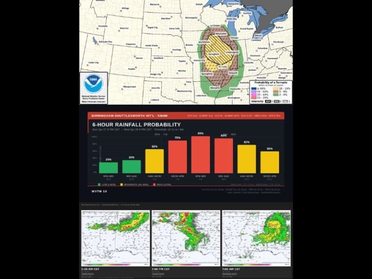
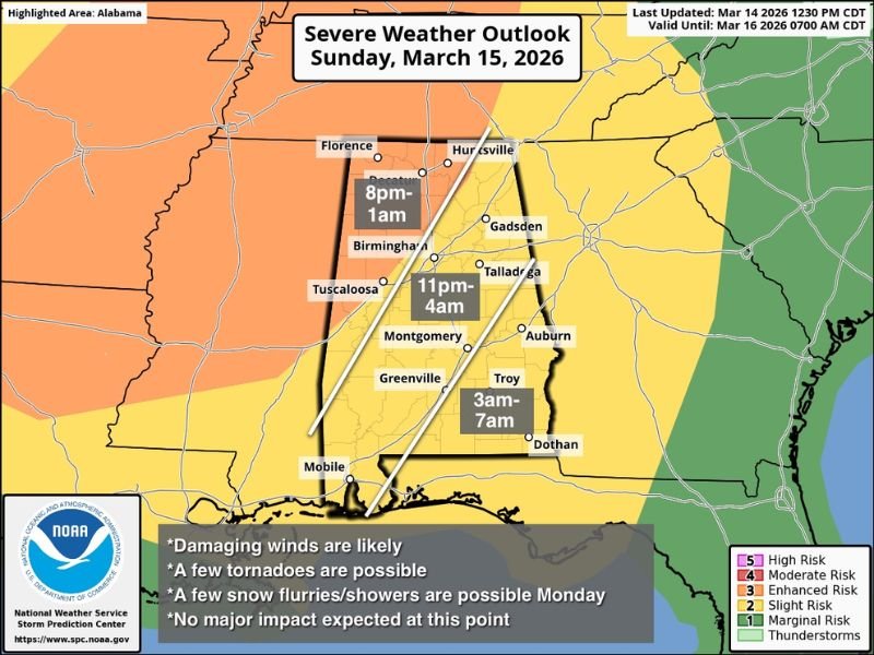
Meteorologists say the storms are expected to form into a long, organized line capable of producing damaging winds, isolated tornadoes, and widespread power outages as they sweep from northwest Alabama toward the southern and eastern parts of the state overnight.
Storm Line Expected to Enter Northwest Alabama Late Sunday
Forecast guidance indicates the line of storms may begin entering northwest Alabama Sunday evening, with the first impacts likely arriving in areas such as Florence and surrounding communities. The expected window for severe weather in northwest parts of the state appears to be between 8 p.m. and 1 a.m., when storms could bring intense wind gusts and heavy rainfall.
Meteorologists say strong wind fields within the atmosphere could allow storms to organize into a squall line capable of producing damaging straight-line winds. Even though the tornado risk is considered limited, forecasters say a few tornadoes cannot be ruled out, particularly within embedded storm cells along the line.
Central Alabama Could See Storms Around Midnight
As the storm system continues moving east and southeast, it is expected to reach central Alabama during the late evening and overnight hours. Cities including Birmingham, Tuscaloosa, and Montgomery could experience the strongest impacts between approximately 11 p.m. and 4 a.m. as the line of storms pushes across the central portion of the state.
During this period, the greatest concern will likely be damaging wind gusts capable of downing trees and power lines. These types of storms can produce widespread wind damage even without tornadoes. Heavy rainfall and frequent lightning may also accompany the strongest storms as they pass through.
Southern Alabama Storm Threat Before Daybreak
The storm line is forecast to continue pushing southward and eastward overnight, eventually reaching southern Alabama communities during the early morning hours Monday. Cities including Troy and Dothan could see storms between 3 a.m. and 7 a.m., bringing the potential for strong winds and heavy rain before the system exits the region.
Because these storms may occur while many residents are asleep, meteorologists are emphasizing the importance of having multiple ways to receive weather warnings overnight. Weather radios, smartphone alerts, and local broadcast updates can provide critical warnings if severe storms intensify.
Cold Air Could Bring Flurries Behind the Storms
After the severe storms move through the region, much colder air is expected to sweep into Alabama on Monday. Meteorologists say that some areas of the state could even see light snow flurries or brief snow showers as the colder air mass moves in behind the departing storm system.
While significant winter impacts are not currently expected, the sudden shift to colder conditions will mark a dramatic change from the warm and stormy weather expected overnight.
Residents Urged to Stay Weather Aware
With severe storms expected during late night and early morning hours, officials are encouraging residents to remain alert and review safety plans ahead of time. Damaging wind gusts from squall lines can cause widespread tree damage and power outages, while isolated tornadoes can develop quickly with little warning.
Residents should ensure that weather alerts are enabled on mobile devices and be prepared to move to a safe shelter area if warnings are issued overnight. If severe weather impacts your community Sunday night or early Monday, share updates and local conditions with the newsroom at SaludaStandard-Sentinel.com so others can stay informed as the storm system moves across the Southeast.