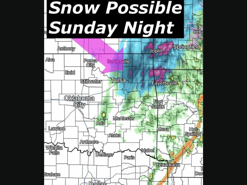
Oklahoma Weather Takes Sudden Turn as 70 Degree Warmth Gives Way to Possible Snow Sunday Night Across Tulsa Region
OKLAHOMA — After enjoying unusually warm temperatures earlier in the day, parts of Oklahoma could see a surprising return of winter weather as a cold front sweeps across the region Sunday night.
Forecasters say the same system bringing rain and storms to parts of the southern Plains may transition into light snow across northeastern Oklahoma as colder air quickly moves in behind the front. While significant snowfall is not expected, meteorologists say a few communities could briefly see the ground whiten if temperatures drop fast enough overnight.
Warm Start to the Day Before a Rapid Weather Shift
The forecast scenario highlights just how quickly weather conditions can change across Oklahoma during the spring transition. Temperatures earlier in the day are expected to climb into the 70s across parts of the state, creating mild and springlike conditions during the afternoon.
However, as evening approaches, a surge of colder air will begin pushing southward, allowing precipitation to transition from rain into snow in some areas. Such rapid temperature swings are common across the Plains during March when winter and spring air masses frequently collide.
Northeastern Oklahoma Could See Light Snow
Forecast models suggest the best chance for snow will occur across northeastern Oklahoma, including areas near Tulsa, Bartlesville, and surrounding communities. Snow bands may briefly develop late Sunday night as colder air settles into the region.
The expected snowfall appears relatively light, with forecasters saying some areas may see only a light coating if accumulation occurs at all. Because ground temperatures will still be relatively warm from earlier sunshine, most snow is expected to melt quickly.
Rain and Storms Expected in Southern Areas
While snow may fall in the northeastern part of the state, other regions could experience very different weather conditions.
Rain showers and thunderstorms are expected to continue across portions of southeastern Oklahoma and nearby Arkansas, including areas near Fort Smith, Fayetteville, and Texarkana. This contrast highlights the sharp temperature boundary moving across the region as the weather system progresses eastward.
Rapid Weather Changes Common in Oklahoma
Meteorologists say Oklahoma frequently experiences dramatic weather swings during the transition from winter to spring. A warm afternoon followed by overnight snow may sound unusual, but such shifts can occur when strong cold fronts collide with lingering warm air. The approaching system is another reminder of how unpredictable March weather can be across the central United States.
Minor Impacts Expected Despite Snow Chance
Despite the possibility of snowfall, forecasters say this event is unlikely to create major travel problems. Most accumulations are expected to remain light, and any snow that does fall should melt quickly once temperatures rise again during the following day.
Still, residents across northeastern Oklahoma are encouraged to stay aware of changing conditions overnight as the system passes through. Readers who experience unusual weather shifts in their communities are invited to share their photos and reports with the SaludaStandard-Sentinel.com community.