Alabama Weather Alert: Heavy Storms and Polar Cold Front Could Bring Strong Winds Late Sunday Into Monday
ALABAMA — A powerful cold front expected to sweep across the Deep South late Sunday night into early Monday morning could bring a line of heavy thunderstorms across Alabama as a surge of polar air pushes into the region. Meteorologists say the approaching system may produce strong wind gusts and small hail, though widespread severe weather is not currently expected.
The storm system is forecast to move into Mississippi Sunday evening before pushing eastward across Alabama overnight, bringing a band of intense rainfall and thunderstorms that could impact travel and early morning commutes.
Storm Line Expected to Enter Alabama Late Sunday Night
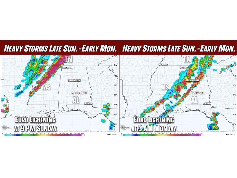
Forecast models show a developing line of storms forming across Mississippi and western Tennessee Sunday evening before advancing toward Alabama. By late evening, the storm line could approach the western portion of the state with pockets of heavy rainfall and lightning.
Radar projections suggest the storms could reach the northwestern parts of Alabama near the Mississippi border around 9 PM Sunday, gradually moving southeast through the overnight hours. As the system progresses eastward, storms may strengthen briefly as they encounter warmer air ahead of the advancing cold front.
Cities such as Florence, Birmingham, and surrounding communities in northern Alabama could experience thunderstorms during the overnight period.
Early Monday Morning Storms Could Affect Central Alabama
By the early hours of Monday morning, the storm line is expected to shift farther into central Alabama. Forecast projections indicate thunderstorms could still be ongoing around 3 AM Monday, potentially impacting communities including Birmingham, Montgomery, and nearby areas.
Heavy rainfall and frequent lightning may accompany the storms, and gusty winds could develop within stronger cells. While meteorologists currently believe the environment is only marginally supportive of severe weather, some storms may still produce isolated strong wind gusts or small hail. Drivers traveling overnight or early Monday morning could encounter sudden downpours and reduced visibility as the storms pass through.
Strong Cold Front Brings a Surge of Polar Air
The storms are developing ahead of a powerful cold front pushing southward with a surge of much colder polar air. Once the front passes, temperatures across Alabama are expected to drop quickly as colder air moves into the region.
Forecasters say this incoming air mass could set the stage for a significant cold snap next week, with the possibility of damaging freeze conditions in some areas. This sudden shift from warm, stormy weather to colder conditions is typical during early spring when strong frontal boundaries move across the southern United States.
Severe Weather Risk Currently Appears Limited
At this time, meteorologists do not expect widespread severe storms across Alabama with this system. However, the atmospheric setup late Sunday night remains somewhat borderline, meaning conditions could still evolve.
Weather experts note that forecasts often change as storms approach, and small shifts in atmospheric instability or wind patterns could allow stronger storms to develop. Because of this uncertainty, residents are encouraged to monitor forecast updates over the next couple of days.
For now, the main threats appear to be heavy rain, lightning, gusty winds, and brief periods of strong thunderstorms as the line of storms sweeps across the state.
Residents Urged to Stay Alert as Forecast Evolves
While many storms during this time of year pass without major impacts, meteorologists say occasional systems can intensify quickly with little warning. Staying informed about updated forecasts is important, especially for residents planning overnight travel Sunday or early Monday.
As the cold front approaches, weather conditions across Alabama could change quickly from calm to stormy and then sharply colder. Readers across the region can follow ongoing updates and share storm reports or weather observations with the community by visiting SaludaStandard-Sentinel.com.