Alabama Severe Weather Alert: Isolated Tornadoes and Damaging Winds Most Likely Across Southern Alabama Over the Next Several Hours
ALABAMA — Meteorologists say the highest risk of isolated tornadoes and damaging wind gusts will focus across the southern half of Alabama over the next four to five hours, as a line of strong thunderstorms moves through the region Wednesday evening.
According to the latest severe weather outlook, conditions across southern Alabama remain favorable for storms capable of producing strong winds and brief tornadoes, while the threat across northern Alabama is expected to remain very low. Weather officials continue monitoring storm development as the system tracks across the state late Wednesday and into the overnight hours.
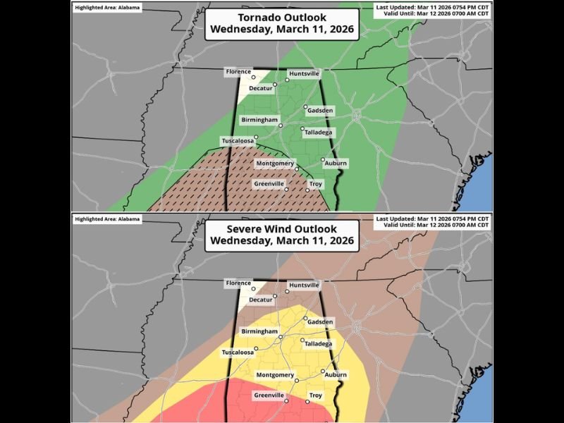
Southern Alabama Faces Highest Tornado Risk Tonight
Forecasters say the tornado outlook highlights the greatest concern across southern counties, including areas near Montgomery, Greenville, and surrounding communities.
These areas currently sit within a zone where atmospheric conditions could support isolated tornado development, particularly as storms interact with warm, unstable air near the Gulf Coast. While tornado activity is expected to remain limited, meteorologists say a few brief tornadoes cannot be ruled out as the storm line moves through.
Damaging Wind Threat Expands Across Central Alabama
In addition to the tornado threat, damaging wind gusts remain a primary concern across a broader portion of the state. The severe wind outlook places central and southern Alabama—including cities like Birmingham, Tuscaloosa, Montgomery, and Auburn—within a corridor where strong storms could produce gusty winds capable of causing damage.
Strong winds within thunderstorm cells could lead to downed trees, power outages, and hazardous driving conditions, especially during heavy rainfall.
North Alabama Expected to See Minimal Severe Storm Activity
Meteorologists say the northern portion of Alabama, including areas around Huntsville, Florence, and Decatur, is expected to experience a much lower severe weather risk.
While scattered showers and thunderstorms may still occur, the environment in these areas is less favorable for severe storm development, reducing the likelihood of tornadoes or damaging winds. Forecasters say the strongest storms should remain focused farther south where atmospheric instability remains higher.
Storm Threat Expected to Continue Through the Night
The severe weather outlook remains valid through the overnight period as storms continue tracking east across Alabama. Officials say residents in southern and central parts of the state should remain weather aware through the evening and overnight hours, especially in areas where tornado risk is highlighted.
Meteorologists recommend keeping weather alerts enabled on mobile devices and having a plan in place to quickly seek shelter if warnings are issued. Weather officials will continue monitoring radar and storm development throughout the night as the system moves across Alabama. Stay with Saluda Standard-Sentinel for the latest updates as severe weather unfolds across Alabama and the southeastern United States.