Massive Supercell Producing Tornadoes Moves From Kankakee Illinois Toward Lake Village Indiana With Destructive Radar Signature
ILLINOIS — A massive rotating supercell thunderstorm produced tornadoes Tuesday evening as it tracked from Kankakee, Illinois toward Lake Village, Indiana, displaying a classic and highly dangerous radar signature that meteorologists say indicated an extremely intense storm structure.
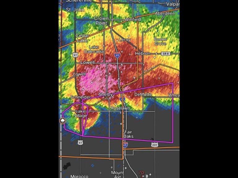
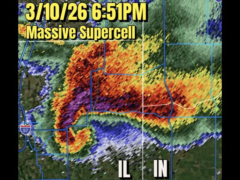
Radar imagery captured during the event showed a powerful storm with a pronounced hook-shaped formation — a hallmark of tornado-producing supercells. The storm intensified rapidly as it crossed northeastern Illinois and moved toward northwestern Indiana, creating conditions capable of producing large tornadoes and destructive hail.
Weather analysts described the storm’s radar appearance as exceptionally strong, with a thick hook echo suggesting the storm had developed into a high-precipitation supercell capable of producing dangerous severe weather.
Classic Hook Echo Reveals Powerful Tornadic Supercell
Meteorologists monitoring the storm observed a classic hook-shaped radar signature as the supercell strengthened. This type of radar pattern forms when a rotating updraft pulls precipitation around the back side of a thunderstorm, creating the curved “hook” shape often associated with tornado development.
The radar presentation around 6:51 p.m. showed a dense and extremely intense storm core with deep red and purple reflectivity values. These colors indicate very heavy precipitation and hail within the storm.
Such radar signatures often signal storms capable of producing long-lived tornadoes, particularly when the hook becomes thicker and more defined.
Tornado Becomes Wrapped in Heavy Rain
As the storm intensified, meteorologists noted that the tornado likely became wrapped in heavy rain — a phenomenon known as a rain-wrapped tornado.
In these situations, the tornado becomes difficult to see because it is surrounded by intense rainfall. This can make the storm even more dangerous because people may not realize a tornado is approaching.
Weather experts also described the tornado briefly “wedging out,” meaning the funnel likely widened significantly and became embedded within the larger storm structure. When this occurs, the tornado can appear as though the entire storm base is touching the ground.
Large Hail and Violent Winds Reported With the Storm
Along with the tornado threat, the supercell produced extremely large hail and intense wind gusts as it moved across the region.
Meteorologists described the storm as having a “green wall” appearance on radar, a common visual indicator associated with heavy precipitation and large hail cores. Hail produced by powerful supercells can sometimes reach the size of large fruit when storms reach peak intensity.
These storms can produce millions of hailstones that travel within the rotating storm core before falling across communities in the storm’s path.
Storm Moves Toward Indiana Overnight
After producing tornadoes near Kankakee, the powerful supercell continued moving eastward toward Lake Village and other communities in northwestern Indiana.
Meteorologists expect storms like this to remain dangerous as they cross state lines, particularly when the atmospheric environment continues supporting rotating thunderstorms.
Forecasters continue monitoring the system as it moves deeper into Indiana, where additional severe weather threats could occur.
Residents across northern Indiana and nearby areas are urged to remain alert for weather warnings and seek shelter immediately if tornado warnings are issued.
Readers who witnessed the storm or experienced severe weather in their communities can share their experiences and follow ongoing updates at SaludaStandard-Sentinel.com.