Illinois Faces Explosive Tuesday Storm Setup With 80° Heat, Rare Spring Humidity and Threat of Large Hail, 70 MPH Winds and Possible Tornadoes
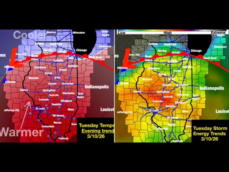
ILLINOIS — Meteorologists are closely analyzing a volatile weather setup expected to develop across Illinois on Tuesday, March 10, where an unusual surge of warm and humid air could fuel powerful thunderstorms later in the day.
Forecasters say the combination of near-80° temperatures, rare early-season humidity, and strong atmospheric wind shear may create an environment capable of producing severe storms across much of the state Tuesday afternoon and evening.
Storm hazards could include large hail, damaging winds approaching 70 mph, and the possibility of isolated tornadoes, particularly in central and northern Illinois.
Warm Front Pulls Unseasonably Warm Air Into Illinois
The setup begins with a warm front lifting north across Illinois, allowing warm, moisture-rich air from the south to surge into the region.
Temperatures across parts of the state are expected to climb toward 80 degrees, which is significantly warmer than typical early-March conditions. At the same time, dew points could rise into the mid- to upper-60s, creating a humid atmosphere more commonly seen during late spring.
Meteorologists say this warm, moist air mass will act as fuel for thunderstorm development once lifting mechanisms along the frontal boundary begin triggering storms.
Powerful Storm Energy Developing Across the State
One of the most important ingredients in Tuesday’s setup is the potential for extremely high CAPE — Convective Available Potential Energy, which measures the amount of energy available for storms to grow.
Forecast models suggest CAPE values could reach 2,000 to 3,000 or higher in parts of Illinois, providing strong updraft potential for thunderstorms.
When storms develop in environments like this, they can rapidly intensify and produce very large hail, with forecasters noting that hail as large as tennis balls cannot be ruled out in central Illinois. Even areas outside the strongest storm zones could still experience hail-producing storms.
Damaging Wind Threat Increasing
In addition to the instability in the atmosphere, meteorologists say strong wind shear will also be present, another critical factor in severe storm development.
A low-level jet of roughly 30–40 knots combined with mid-level winds of 45–50 knots could transfer powerful momentum toward the ground during thunderstorms. If storms tap into these winds, damaging gusts approaching 70 miles per hour could occur, especially in stronger storm cells.
Tornado Potential Also Being Monitored
The combination of changing wind directions with height — known as directional shear — and strong storm energy could allow thunderstorms to rotate.
Rotating storms, known as supercells, are capable of producing tornadoes. Meteorologists say the tornado risk currently appears isolated but possible across much of Illinois, particularly Tuesday evening as storms mature.
Central Illinois May See Enhanced Tornado Risk
Forecasters are paying close attention to central and northern Illinois, where the interaction between the warm front and a developing low-pressure system over Iowa could create a critical atmospheric feature known as a triple point. Triple points are areas where multiple air masses collide and often become prime locations for severe storm development.
Because of this setup, meteorologists say central Illinois could experience an enhanced tornado risk if storms develop in the right location. While it remains too early to determine the exact track or intensity of storms, a stronger tornado cannot be completely ruled out in the region.
Forecast Details Still Evolving
Despite the concerning ingredients in place, meteorologists caution that smaller-scale weather features will ultimately determine exactly how storms develop Tuesday evening. Subtle shifts in the warm front, storm timing, or atmospheric energy could change which areas experience the strongest storms.
Forecasters will continue monitoring model updates as the system approaches. Residents across Illinois and nearby states are encouraged to stay weather aware Tuesday afternoon and evening as conditions evolve.
Stay with SaludaStandard-Sentinel.com for the latest updates as meteorologists track this developing severe weather setup across the Midwest.