Explosive Thunderstorms Slam Houston, Texas With Intense Lightning, 40 MPH Winds and Hail as Powerful Storm Cells Push Across the City
HOUSTON, TEXAS — Strong thunderstorms swept across the Houston metropolitan area Friday evening, producing intense lightning, bursts of heavy rain, gusty winds, and small hail as powerful storm cells moved through the region.
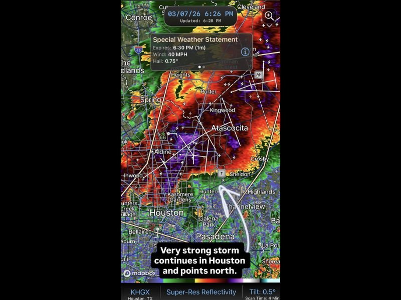
Radar imagery around 6:30 p.m. local time showed a large cluster of storms pushing across northern and northeastern sections of Houston, including areas around Spring, Porter, Kingwood, Atascocita, and Aldine.
Meteorologists warned residents to remain cautious as the storms produced frequent lightning, heavy rainfall, and gusty winds capable of reaching around 40 miles per hour.
Radar Shows Powerful Storm Cells Moving Across Houston
Weather radar indicated a strong line of thunderstorms stretching from north of Houston down through central portions of the metro area, with some of the most intense storm cores located over communities near Porter Heights, Kingwood, and Atascocita.
Bright red and purple radar returns suggested extremely heavy rainfall within the strongest cells, while lightning detection showed dozens of lightning strikes occurring across the storm system.
The storms appeared to be moving generally southward and southeastward across the city during the evening commute period, increasing the potential for localized travel disruptions.
Special Weather Statement Issued for the Area
A Special Weather Statement was issued for parts of the Houston area as the storms intensified.
According to the advisory, the storms were capable of producing wind gusts up to 40 mph along with hail measuring around three-quarters of an inch in diameter.
While these storms were not initially classified as severe thunderstorms, meteorologists noted that the strong lightning activity and brief bursts of heavy rain could still create hazardous conditions for drivers and residents outdoors.
Lightning and Heavy Rain Create Dangerous Conditions
The storm system generated frequent lightning across much of the northern Houston metro, making outdoor activities dangerous during the height of the storms.
Heavy rainfall also created brief periods of reduced visibility on roadways as the storm cores passed through the area.
In addition to lightning and rain, isolated hail reports were possible within the strongest storm cells moving through the region.
Storms Continue Moving Across Southeast Texas
Forecasters say the storms could continue tracking across portions of southeast Texas through the evening as the weather system gradually shifts across the region.
While the strongest activity was concentrated north of downtown Houston, residents across the metro area were advised to monitor local weather updates in case the storms strengthened further.
Officials recommend staying indoors during lightning storms and avoiding flooded roads if heavy rain develops.
Residents who capture photos or videos of the storms across the Houston area can share them with our newsroom at SaludaStandard-Sentinel.com as we continue covering major weather developments across the United States.