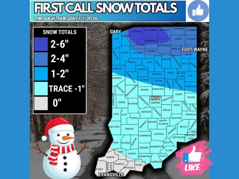
Powerful Storm System Could Trigger Tornadoes, Giant Hail and Damaging Winds From Texas to the Ohio Valley Tuesday and Wednesday
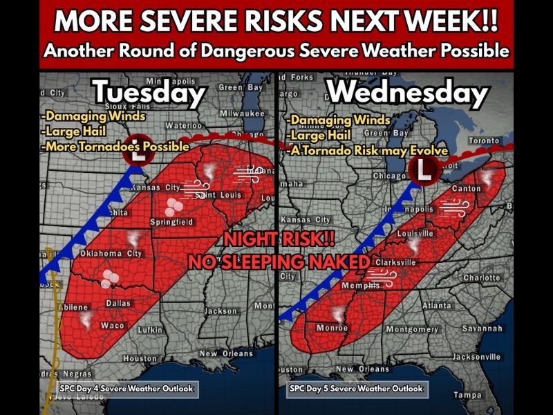
UNITED STATES — Meteorologists are closely monitoring another potentially dangerous severe weather setup developing for early next week, with Tuesday and Wednesday emerging as the next major threat window for storms across the central and eastern United States.
Forecast guidance indicates that a large storm system will move out of the Plains and track northeast across the country, creating conditions favorable for multiple rounds of severe thunderstorms. Experts say the environment could support all modes of severe weather, including tornadoes, damaging winds, and large hail.
Although the forecast will continue to evolve over the coming days, current projections show the potential for severe storms stretching from Texas and Oklahoma into the Midwest and eventually the Ohio Valley.
Tuesday Severe Weather Threat From Texas to the Midwest
The first round of storms is expected to develop Tuesday afternoon and evening as a powerful system ejects into the Plains.
Forecast maps suggest the most active corridor may extend from north Texas and Oklahoma northeast into Missouri and Illinois, impacting cities such as Dallas, Oklahoma City, Springfield, Kansas City, and St. Louis.
Meteorologists say this setup could support damaging winds, large hail, and the possibility of tornadoes, particularly as warm and moist air surges northward ahead of an advancing cold front.
Storms may intensify through the evening and continue into the overnight hours, raising concerns for communities that could see storms after dark.
Overnight Storm Risk Could Extend Into the Night
One of the biggest concerns with the Tuesday system is the potential for nighttime severe weather.
Storms developing during the evening could continue into the overnight hours as they move east across the central United States. Nighttime tornado events can be particularly dangerous because they occur when many people are asleep and less likely to receive warnings.
Forecasters say the overnight environment could remain favorable for strong winds and rotating storms, depending on how the atmosphere evolves during the day.
Storm System Expected to Expand East on Wednesday
By Wednesday, the storm system is forecast to move farther northeast, spreading severe weather potential into the Mississippi Valley, Tennessee Valley, and parts of the Ohio Valley.
The threat area could stretch from Louisiana and Mississippi northeast through Tennessee, Kentucky, Indiana, and Ohio.
Cities including Memphis, Nashville, Louisville, Indianapolis, and Detroit could see strong storms as the system advances.
While details remain uncertain, meteorologists say the Wednesday storms could again produce damaging winds, large hail, and possibly tornadoes.
Forecasters Continue Monitoring the Developing Pattern
Meteorologists emphasize that several days remain before the storms arrive, meaning exact locations of the highest severe risk may still shift as new forecast data becomes available.
However, the large-scale weather pattern already shows the ingredients needed for widespread thunderstorm development across a broad region of the country.
Officials recommend that residents across the Southern Plains, Midwest, and Ohio Valley stay informed as the forecast becomes clearer in the coming days.
If severe weather affects your community next week, share your reports and storm photos with our newsroom at SaludaStandard-Sentinel.com as we continue tracking severe weather threats across the United States.