Strong Storm Line Expected Across North Alabama and Southern Tennessee Saturday With 60 MPH Winds and Brief Tornado Risk
ALABAMA — A line of strong thunderstorms is expected to move across north Alabama and parts of southern Tennessee Saturday afternoon, bringing the potential for gusty winds, small hail, and a brief tornado risk as the system pushes through the region.
Forecasters say the storms will develop during the afternoon hours and track east across the state. While widespread severe weather is not expected, the Storm Prediction Center continues to place much of Alabama under a Level 1 “Marginal Risk” for severe storms.
Meteorologists say warmer temperatures ahead of the system, with highs approaching 80 degrees, will help fuel thunderstorm development as the storm line moves through.
Storm Timing Expected Through the Afternoon and Evening
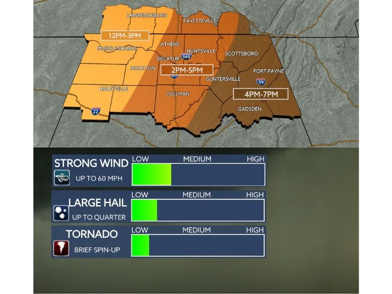
Weather models indicate the storms will move across the region in phases during the afternoon.
The first storms are expected to reach northwest Alabama and the Shoals region between noon and 3 PM, bringing the initial wave of thunderstorms to the area.
As the system moves east, the storms are expected to reach communities along the Interstate 65 corridor including Athens, Decatur, and Huntsville between 2 PM and 5 PM.
Farther east across northeast Alabama and areas near Sand Mountain, storms are expected to arrive later in the day, generally between 4 PM and 7 PM.
Residents across the region should expect periods of heavy rain, lightning, and gusty winds as the storms move through.
Damaging Winds Main Concern With Storm System
Meteorologists say the primary threat from Saturday’s storms will be strong wind gusts, which could reach speeds of up to 60 miles per hour in some locations.
Winds of this strength can break tree limbs, knock down power lines, and cause isolated power outages, especially where stronger thunderstorm cells develop.
Heavy rainfall may also reduce visibility for drivers and create brief travel hazards during the afternoon commute hours.
Officials recommend securing loose outdoor items and staying alert for changing weather conditions as the storms approach.
Small Chance for Hail and Brief Tornado Spin-Ups
In addition to gusty winds, forecasters say a small chance of hail exists within the strongest storm cells. Some hailstones could reach quarter size, though widespread large hail is not expected.
Meteorologists also say the tornado threat is low but not zero. Any tornado activity that develops would likely be brief and occur within rotating storm segments embedded in the line of storms.
Northwest Alabama currently appears to have the greatest potential for these brief spin-up tornadoes if atmospheric conditions allow storms to organize more strongly.
However, experts say relatively weak wind shear in the atmosphere may limit the ability of storms to become more intense.
Residents Encouraged to Stay Weather Aware
Even though the overall severe weather risk remains relatively low, forecasters are encouraging residents across north Alabama and southern Tennessee to remain alert throughout Saturday afternoon and evening.
Thunderstorms can strengthen quickly, and conditions may change rapidly as the storm line moves through the region.
Residents are encouraged to monitor weather alerts, keep mobile notifications active, and be prepared to move indoors if severe thunderstorms develop.
If strong storms impact your community Saturday, share your weather photos and updates with our newsroom at SaludaStandard-Sentinel.com as we continue tracking storm developments across the United States.