Cold Front to Bring Isolated Showers and Thunderstorms Across Oklahoma With Small Hail Possible as Rain Chances Increase Into Tomorrow
OKLAHOMA — A passing cold front is expected to bring scattered showers and a few isolated thunderstorms across parts of the state tonight into tomorrow, though most areas will remain dry and the overall severe threat remains low.
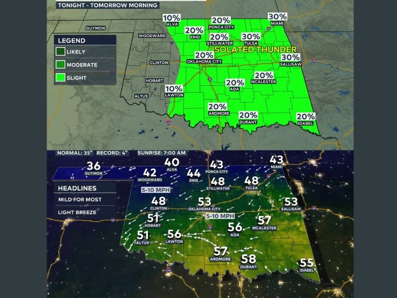
Forecasters indicate that a few isolated showers are possible overnight, but widespread rainfall is not expected. Many communities may not see measurable precipitation tonight.
Rain Chances Increase Slightly Tomorrow
As the cold front pushes through the state tomorrow, rain chances will improve slightly compared to tonight. Storms are expected to develop along the frontal boundary, particularly during the daytime and into the afternoon hours.
Coverage is not expected to be widespread, with most areas seeing only a 20% to 30% chance of precipitation. Cities such as Tulsa, Miami, and Sallisaw could see slightly higher rain probabilities, while central and southern communities including Oklahoma City, Ardmore, Durant, and Ada are expected to remain near the 20% range.
Western Oklahoma will likely stay mostly dry.
Severe Threat Very Low, But Small Hail Not Ruled Out
The overall severe weather risk remains minimal with this system. However, forecasters note that a few storms could briefly become strong enough to produce small hail.
Widespread damaging winds or tornadoes are not expected at this time, but residents are encouraged to stay weather-aware in case any isolated storms briefly intensify.
Temperatures and Conditions
Overnight lows are expected to dip into the 40s and low 50s across much of the state. By tomorrow afternoon, temperatures will rebound into the 70s in many southern areas, with cooler conditions lingering in northern Oklahoma behind the front.
Wind speeds may increase slightly as the front moves through, but no significant wind advisories are anticipated.
While this system does not appear to be a major weather event, it serves as a reminder that springlike frontal boundaries can still trigger isolated thunderstorms even when overall risk levels remain low.
Are you seeing showers in your area tonight? Share your local conditions with us at SaludaStandard-Sentinel.com.