Dangerous Arctic Blast Set to Hit Ohio: Wind Chills Could Plunge Into the –20s by Tuesday
OHIO — A dangerously cold stretch is about to lock in across Ohio, with forecasters warning that Tuesday could bring life-threatening wind chills plunging into the –20s. The upcoming outbreak is being described as one of the coldest periods seen in years, with impacts that could shut down schools and disrupt daily activities across northern and central counties.
Wind Chills Dive Below Zero Sunday, Then Even Worse by Tuesday
Wind chills are expected to fall well below zero on Sunday, followed by a brief and only slightly warmer break on Monday. By Tuesday, however, conditions deteriorate again — this time dramatically — with the potential for extreme, dangerous cold spreading across much of the state.
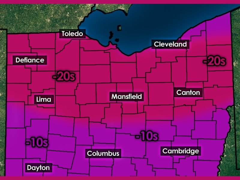
Forecasters note that the northwestern and northeastern regions may experience the harshest conditions, with wind chills labeled in the –20s on the map, including areas near Toledo, Defiance, and regions east of Cleveland.
Central and Southern Counties Also Face Severe Cold
The map shows wind chills in the –10s extending across:
- Columbus
- Dayton
- Cambridge
- Lima
- Surrounding central and southern counties
Although not as extreme as the –20s farther north, these values still represent a dangerous and bitterly cold environment, capable of causing frostbite in short periods of time.
Forecaster Explains Why This Extreme Pattern Is Forming
The update attributes the incoming deep freeze to a complex atmospheric setup involving:
- Polar vortex pieces breaking apart
- Teleconnections lining up
- A rapidly shifting jet stream
This chain reaction is described as both rare and fascinating, responsible for funneling arctic air directly into the region. For meteorologists, the alignment of these factors is unusual — but for residents, the result will be dangerously low wind chills.
School Closures Likely as Hazardous Cold Expands
The post warns that this level of cold is the kind that “shuts things down.”
With wind chills falling into the –20s and –10s, school closures are very likely, especially across northern Ohio where the most intense cold is projected.
Local officials and residents are encouraged to prepare for disruptions on Tuesday, particularly early in the morning when conditions are expected to be most severe.
Residents Urged to Monitor Updates as Dangerous Cold Approaches
Although the pattern is increasingly clear, forecasters will continue refining details as Tuesday draws closer.
The message remains consistent: this is a dangerous cold outbreak, and residents should monitor local alerts, take precautions and limit exposure whenever possible.
Readers can share their local cold-weather conditions and preparedness tips at SaludaStandard-Sentinel.com.