Illinois, Iowa, and Missouri Bracing for Up to 10 Inches of Heavy Snow as Major Midwest Storm Targets Region This Weekend
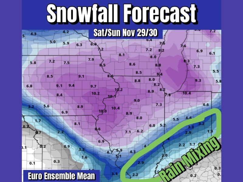
ILLINOIS — A major winter storm system is expected to impact the Midwest this weekend, with the European weather model (EURO) ensemble indicating a wide corridor of 6 to 10 inches of snow across Illinois, Iowa, and Missouri, as the first significant snowfall of the season takes aim at the region.
The bulk of the snow is forecast to fall between Saturday, November 29, and Sunday, November 30, with widespread travel disruptions, low visibility, and strong winds likely across much of the Midwest.
Heavy Snowfall Corridor Takes Shape
According to the EURO ensemble mean forecast, the heaviest snow bands are projected to form from eastern Iowa through central Illinois and into western Indiana. Accumulations within this zone could range between 8 and 10 inches, with some localized areas possibly exceeding that threshold if snowfall rates intensify overnight Saturday.
Cities expected to experience the heaviest snow include:
- Des Moines, Iowa
- Peoria and Springfield, Illinois
- Quincy and Bloomington, Illinois
- Columbia, Missouri
The National Weather Service and independent meteorologists are urging travelers and residents to prepare for hazardous driving conditions as roadways quickly become slick and snow-covered late Friday into the weekend.
“This is shaping up to be a classic early-season Midwest winter storm,” forecasters said Friday. “Confidence is increasing in widespread heavy snow totals of 6 inches or more for many areas.”
Rain and Mix Possible Along the Southern Edge
While the central Midwest will see mostly snow, the southern edge of the storm system — particularly in parts of southern Illinois, southeast Missouri, and western Kentucky — may experience rain mixing in during the latter half of the event.
This warmer air intrusion could cause snowfall to melt on contact in some areas, creating a sharp southern cutoff line where accumulation totals drop rapidly from 6 inches to just 1 or 2.
“This system has strong moisture inflow from the Gulf, which is feeding warmer air into the southern flank,” one meteorologist explained. “That could lead to a mix of rain and sleet that cuts down on totals south of I-70.”
Despite this, even mixed-precipitation zones will likely face slippery travel conditions and possible icing, especially during overnight hours.
Timing and Impacts
The primary window for heavy snow is expected between Friday night and Saturday evening, gradually tapering off by early Sunday morning. The heaviest snow rates — up to 1 inch per hour at times — are likely during the overnight period into early Saturday.
Forecast highlights include:
- Timing: Late Friday night through Sunday morning
- Snowfall: 6–10 inches across central Illinois, 4–8 inches in Iowa and Missouri
- Wind Gusts: 20–30 mph, potentially creating blowing and drifting snow
- Rain/Mix Zone: Southern Illinois and western Kentucky
Major interstates — including I-55, I-70, and I-74 — could experience slowdowns, reduced visibility, and hazardous travel through much of Saturday.
Travel and Safety Precautions
Authorities are urging drivers to avoid unnecessary travel during the height of the storm and to keep emergency kits stocked with blankets, flashlights, and nonperishable food in their vehicles.
Snowplow operations and road treatment will begin ahead of the storm’s arrival, but forecasters warn that accumulations may outpace plowing efforts in the heaviest-hit zones.
Residents are also encouraged to:
- Clear sidewalks and driveways early before temperatures plunge.
- Protect pets and livestock from exposure.
- Check on elderly neighbors and ensure heating systems are functioning safely.
Looking Ahead
Once the system exits Sunday, temperatures across the Midwest will remain well below freezing, allowing snowpack to linger into the start of December.
Meteorologists expect improved model clarity by Friday, as new data helps refine the southern boundary of snowfall versus rainfall. Regardless of mixing issues, the consensus remains that a significant snow event is imminent across Illinois, Iowa, and northern Missouri.
Stay updated with SaludaStandard-Sentinel.com for detailed weekend weather forecasts and post-storm coverage across the Midwest.