70 MPH Severe Storm Warning Strikes Graham Texas as Damaging Winds Hail and Heavy Rain Spread Across North Texas Friday
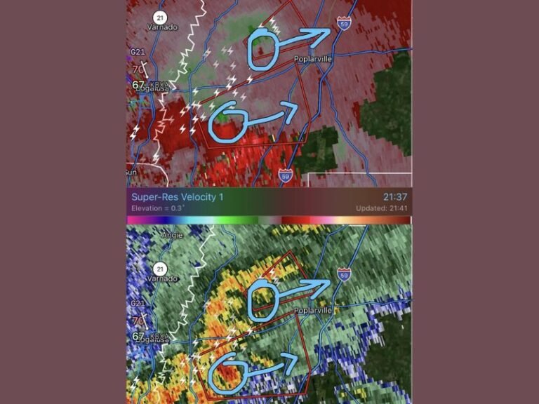
DALLAS, TX — A severe thunderstorm warning was issued for Graham, Texas at 2:30 AM Friday with wind gusts reported up to 70 mph, marking the start of a widespread severe weather event expected to push across North Texas through the morning and into the early afternoon hours.
Storms Build Rapidly Across West Texas
Thunderstorms began developing west of the Dallas-Fort Worth metroplex overnight, with activity intensifying as the system moved eastward. The severe warning issued for Graham included confirmed wind gusts reaching 70 mph, well above severe thresholds, signaling the potential strength of storms expected to follow throughout the morning.
Additional cells were expected to become more numerous over the following hours as the line of storms organized and continued tracking toward the Dallas-Fort Worth area and points east.
North Texas Faces Hours of Active Weather
The storm complex is forecast to arrive across North Texas after sunrise Friday and remain active through approximately 1 PM before exiting the region. Areas including Denton, Dallas, and Corsicana are expected to see the most direct impacts as the system tracks southeast through the morning hours.
Gusty winds between 40 and 60 mph are expected with the overall complex, with stronger embedded cells capable of producing gusts similar to the 70 mph reading recorded near Graham. Small hail and frequent lightning are also expected to accompany the stronger storm cores.
Heavy Rainfall Threatens Flooding Concerns
Pockets of heavy rain are forecast within the storm bands, with roughly 70 percent of the affected area expected to see measurable rainfall by the time the system clears. Rainfall totals between 1 and 3 inches are possible in areas that experience training storm cells, raising the potential for localized flooding.
Communities along and south of the Interstate 35 corridor, including areas near Waco, are also expected to see storm activity push through as the system continues its eastward and southeastward progression through the day.
Conditions Expected to Clear by Afternoon
The severe weather threat is expected to gradually diminish as the complex moves east of the Dallas-Fort Worth area, with conditions improving through the afternoon hours. Residents across North Texas are urged to stay weather-aware through the morning commute as the strongest storms move through.
For continuing coverage of severe weather events and storm impacts across the United States, visit SaludaStandard-Sentinel.com.