Unusually Strong Jet Stream Brings Severe Weather and Strong Winds to the Southern Great Lakes and Ohio Valley Wednesday Night Into Thursday in a Rare Winter Like June Setup
TOLEDO, OH — A powerful and unusually strong weather system is forecast to move through the southern Great Lakes and Ohio Valley region Wednesday night into Thursday, driven by a mid-level jet stream strengthening to a degree more typical of autumn or winter, raising the potential for severe weather and strong winds across a broad corridor stretching from the Plains through the Northeast.
What Makes This System Unusual
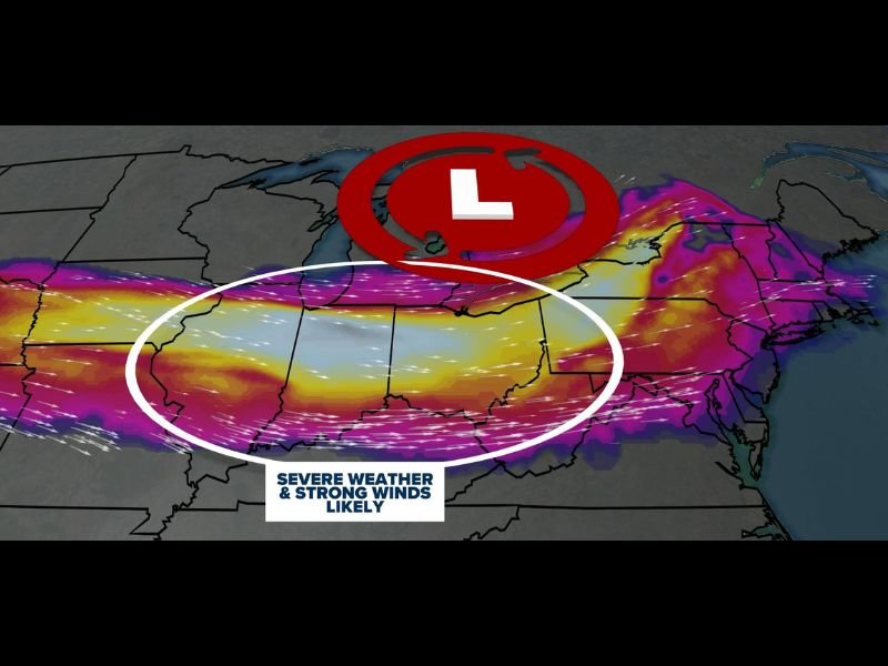
WTOL 11 Weather Impact graphics depict an unusually strong mid-level jet stream setting up across the southern Great Lakes Wednesday, with a strengthening upper-level low pressure system positioned over the Great Lakes region. The jet stream intensity associated with this setup is more characteristic of storm systems seen during the autumn or winter months, making its appearance in June notable and worthy of close attention from forecasters and residents alike.
The strengthening jet stream will increase atmospheric lift — the rising motion responsible for generating clouds, rain, and storms — across a wide area. This enhanced lift, combined with the overall strength of the system, creates conditions favorable for both organized severe thunderstorms and widespread strong, potentially damaging winds independent of thunderstorm activity.
Where the Impacts Will Be Felt
The graphic highlights a broad oval-shaped zone stretching from the Central Plains through the Midwest, Ohio Valley, and into the Mid-Atlantic and Northeast, labeled with severe weather and strong winds likely. This corridor represents the area expected to feel the most significant impacts from the strengthening jet stream and associated storm system as it tracks eastward through Wednesday night and Thursday.
The system’s strength and the breadth of the highlighted impact zone suggest this event has the potential to affect a large population across multiple states simultaneously, with both severe thunderstorm impacts and non-convective wind impacts possible depending on location and timing.
Why This Draws Extra Attention
A storm system of this strength occurring in June, rather than during the more typical autumn or winter window when such jet stream configurations are common, signals an atmospheric setup capable of producing impacts beyond what residents might expect from a typical summer storm system.
Residents across the highlighted corridor should monitor forecasts closely as Wednesday approaches, with additional updates expected as the system’s track and timing become clearer.
For continuing coverage of this developing weather system across the United States, visit SaludaStandard-Sentinel.com.