Texas Hill Country Could See Early Supercell Storms Tuesday Evening With Large Hail and Damaging Winds Before Main System Arrives
TEXAS — Meteorologists are monitoring the potential for isolated supercell thunderstorms to develop across parts of southwest and central Texas Tuesday evening, possibly bringing large hail and damaging winds before a larger storm system arrives later in the night.
Forecast models suggest that one or two storms could form ahead of the main severe weather line, moving northeast across parts of the Texas Hill Country during the late afternoon and evening hours. While the scenario is not guaranteed, forecasters say the possibility cannot be ruled out and will be closely monitored as conditions evolve.
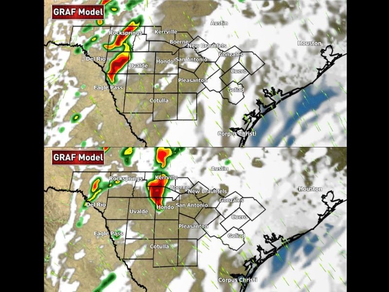
Rogue Supercell Storms Could Develop Ahead of Main Line
Weather model projections show individual storms forming west of San Antonio near Del Rio and Uvalde, then moving northeast toward communities in the Hill Country.
Areas that could potentially see these early storms include:
- Del Rio
- Eagle Pass
- Uvalde
- Rocksprings
- Kerrville
- Hondo
- Boerne
If storms organize into supercells, they could intensify as they track northeast across the region.
Large Hail and Damaging Winds Possible
Forecasters say the main threats from these early storms would likely be large hail and strong wind gusts. Supercell thunderstorms are capable of producing hailstones large enough to cause damage to vehicles, roofs, and outdoor structures.
Damaging wind gusts could also occur as storms strengthen, particularly if powerful downdrafts develop within the storm cores.
Storm Timing Focused on Early Evening
Current forecast guidance suggests the first storms could begin developing around the early evening hours, with models indicating activity near southwest Texas by approximately 6 p.m.
As the storms move northeast, they may reach parts of the Hill Country and areas northwest of San Antonio later in the evening. Additional storms may then develop later at night as the main storm system moves into the region.
Forecast Uncertainty Remains
Meteorologists emphasize that these early storms remain a conditional possibility rather than a certainty.
Some forecast models show only a small number of storms forming ahead of the main line, while others keep conditions quieter until the primary storm system arrives. However, because supercells can produce severe weather quickly, forecasters say the possibility is important enough to monitor closely.
Residents Encouraged to Stay Alert
Communities across southwest and central Texas are encouraged to keep track of weather updates Tuesday afternoon and evening. Even a single supercell storm can produce large hail or damaging winds in a localized area, making it important for residents to stay aware of changing weather conditions.
Stay with SaludaStandard-Sentinel.com for continuing updates as meteorologists track developing storms across Texas and the southern Plains.