Super El Nino Event Forecast for Late 2026 as ECMWF Models Signal Record Warm Pacific Ocean Temperatures Driving a Major Hurricane and Typhoon Season With Wild Fall and Winter Weather Ahead
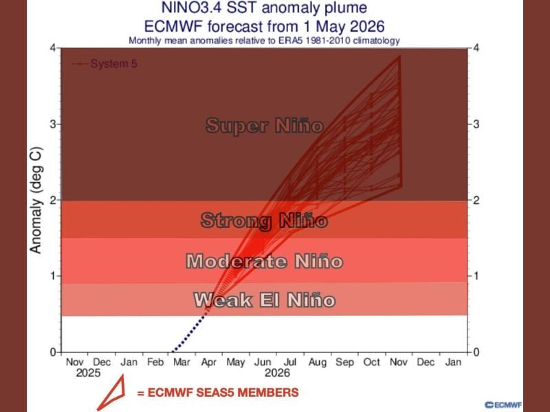
PACIFIC OCEAN — A powerful El Nino event is developing and rapidly intensifying, with the latest ECMWF SEAS5 forecast models issued from May 1, 2026 projecting sea surface temperature anomalies climbing well into Super Nino territory by late 2026. Some of the warmest Pacific Ocean waters seen in quite some time are already forming, setting the stage for a dramatically active hurricane and typhoon season alongside a potentially extreme fall and winter weather pattern.
ECMWF Models Point Toward Super Nino Territory by Late 2026
The NINO3.4 SST anomaly plume from the ECMWF forecast shows a sharp and aggressive departure from neutral conditions beginning as early as mid-2026. Model ensemble members are converging strongly toward anomalies exceeding 3 degrees Celsius, pushing well into the Super Nino classification range by the November through January window of 2026 into 2027.
Pacific Typhoon Season Expected to Become Exceptionally Active
The record warmth building across the Pacific Ocean will provide exceptional fuel for tropical development throughout the basin. Typhoon activity is forecast to surge significantly as sea surface temperatures climb, with conditions becoming increasingly favorable for intense and long-lived storm systems tracking across the western Pacific during the peak season months.
Atlantic Hurricane Season Faces a More Hostile Environment
In contrast to the Pacific, the developing El Nino is expected to suppress Atlantic hurricane activity by increasing vertical wind shear across the basin. This creates a far more hostile environment for longer-tracked tropical cyclones to develop and sustain themselves, potentially keeping the Atlantic season more tame compared to recent years despite overall global ocean warmth remaining elevated.
Fall and Winter 2026 Weather Pattern Could Turn Extreme
Beyond the tropical implications, the strengthening El Nino signal carries significant consequences for fall and winter weather across the United States and globally. Strong to Super Nino events historically drive dramatic shifts in the jet stream, bringing the potential for an exceptionally active and volatile weather pattern as the year closes out. For continuing coverage of climate and severe weather developments across the United States, visit SaludaStandard-Sentinel.com.