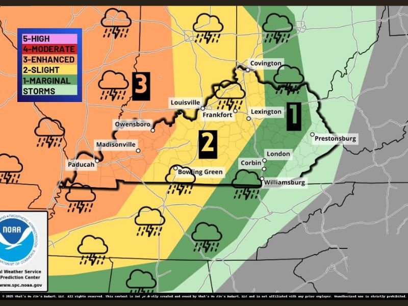
Storm Prediction Center Flags Level 3 Enhanced Severe Storm Threat Across Western Kentucky, Level 2 for Louisville and Bowling Green, Level 1 for Lexington on April 27
KENTUCKY — The Storm Prediction Center has highlighted a severe weather risk across the entire state of Kentucky for April 27, 2026, with the threat level varying significantly depending on how far west you are in the state. Forecasters are urging residents statewide to begin monitoring the situation now, as the outlook is still a few days out and shifts in the risk area remain possible.
The bottom line from forecasters is straightforward — the farther west you are in Kentucky, the greater your chance of encountering severe storms that day.
How the Three Risk Zones Break Down
Western Kentucky is currently sitting inside the Level 3 enhanced risk zone, which represents the highest threat tier in the current outlook for the state. This includes areas around Paducah, Madisonville, and Owensboro, where the best chance for stronger and more active severe storms will be concentrated.
The Level 2 slight risk zone stretches from Bowling Green toward Frankfort, covering a broad middle section of the state including Louisville. Scattered storms are expected in this area, with a few of them potentially turning severe.
Eastern Kentucky, including Lexington and points east such as Corbin, London, Prestonsburg, and Covington, currently sits in the Level 1 marginal risk zone. This represents a low-end isolated threat, though residents in this zone should not completely dismiss the possibility of storm activity on April 27.
What These Risk Levels Actually Mean
The SPC risk scale runs from Level 1 through Level 5. Level 1 marginal indicates isolated severe storm potential with limited coverage. Level 2 slight means scattered storms are expected with a few possibly reaching severe criteria. Level 3 enhanced is where storm activity becomes more widespread and the probability of significant severe weather increases considerably.
Western Kentucky’s placement in the Level 3 zone means residents in that region face a meaningfully higher risk than those in the central or eastern parts of the state. That gap could widen or narrow as the forecast firms up over the coming days.
What Residents Should Do Before April 27
With several days remaining before the threat arrives, now is the right time to review shelter plans, ensure weather alert systems are active on all devices, and stay connected to updated forecasts as new model data comes in.
Forecasters have been clear that the outlook can still shift, and the geographic placement of each risk tier may change before April 27. Residents across all three zones should treat this as an evolving situation and check back for updates regularly rather than assuming the current risk map reflects the final picture.
Stay connected with the latest Kentucky severe weather coverage and share your local storm reports at SaludaStandard-Sentinel.com.