Spring-Like Warmth Set to Surge Across the South and Central U.S. Next Week as Temperatures Run 15–20 Degrees Above Normal
UNITED STATES — A dramatic warm-up is on the way for much of the South and central United States, with spring-like temperatures expected to take hold starting late this week and intensify into next week as Arctic air retreats and a strong ridge of high pressure expands eastward.
Forecasters say the shift will bring several consecutive days of well-above-average temperatures, with some locations climbing into the upper 70s and even near 80 degrees, a striking change for early February.
Big Warm-Up Begins Late This Week
The transition toward warmer weather begins as early as tomorrow afternoon, when many areas see highs pushing above 70 degrees for the first time in weeks. The pattern change is driven by Arctic air pulling back northward and the polar vortex consolidating deeper into the Arctic, removing the supply of cold air that has dominated much of winter so far.
A southwest flow off the Pacific combined with strengthening upper-level ridging will allow temperatures to surge quickly. By Friday, parts of the South could approach 80 degrees, with upper 70s expected to hold through the Super Bowl weekend.
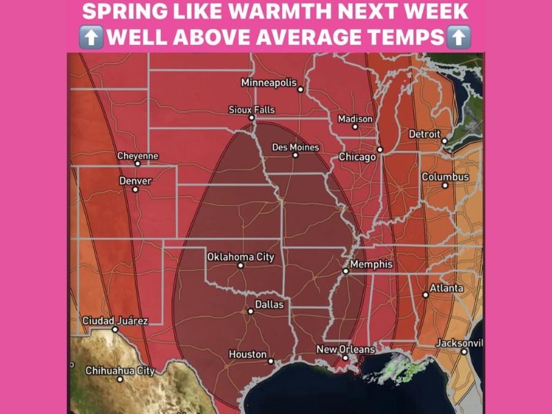
Next Week’s Pattern Favors Unseasonable Heat
Looking ahead to next week, the ridge of high pressure is forecast to expand eastward and strengthen over the central United States, locking in warmer conditions for several days.
For context, the average high temperature this time of year is near 60 degrees across much of the central U.S. Instead, areas including North Texas, Oklahoma, Louisiana, Mississippi, and portions of the Southeast may run 15 to 20 degrees above normal, with daytime highs commonly reaching the mid-70s to near 80 degrees.
This setup favors dry, mild afternoons, making it feel far more like March or April than early February.
Rain Chances Remain Limited but Possible
Despite the warm pattern, rain chances remain limited. Forecast guidance currently shows two weak opportunities for rainfall next week — one around Tuesday and another near Valentine’s Day.
At this time, neither system looks particularly impressive, though forecasters note there is still time for the setups to evolve as they move inland. Rain would be welcome in many areas, as parts of the South are now running more than four inches below average precipitation for the winter season.
What This Means Going Forward
While winter is not officially over, the current outlook shows no significant cold air intrusions on the horizon. Any return to colder temperatures appears unlikely in the immediate future, allowing this spring-like pattern to dominate much of next week.
Residents are encouraged to enjoy the warmer weather but remain mindful that February can still deliver surprises, even after extended mild stretches.
For continued updates on temperature trends, rainfall chances, and long-range outlooks impacting the Southeast and beyond, stay with SaludaStandard-Sentinel.com and check back daily for the latest weather coverage.