Spring Is Arriving Earlier, Hotter, and Wetter Across the Carolinas and U.S., New Data Shows
SOUTH CAROLINA — Across the United States — and right here in the Carolinas — spring is undergoing a dramatic transformation. According to recent reports from the Environmental Protection Agency (EPA) and the National Oceanic and Atmospheric Administration (NOAA), spring now arrives significantly earlier in many parts of the country, with average temperatures climbing and rainfall totals increasing. The changes are subtle in some regions, but the long-term trend is reshaping ecosystems, weather patterns, agriculture, and public health.
These shifts are part of a broader climate trend that researchers say is tied to human-caused global warming, and they’re already affecting day-to-day life in communities from Greenville, South Carolina to Charlotte, North Carolina.
Spring is now arriving weeks earlier in many parts of the country
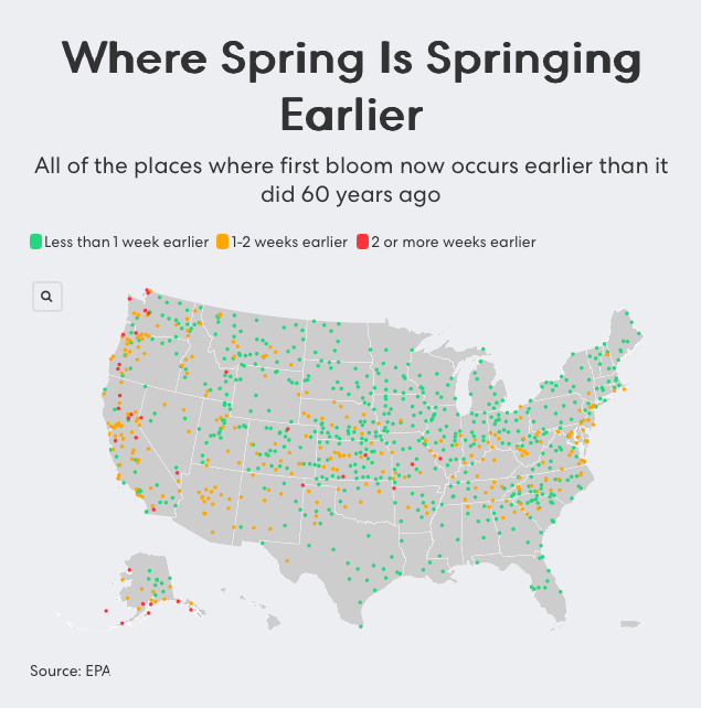
Federal climate scientists analyzing bloom data over the last 60 years found that first blooms — the point when plants like lilacs and honeysuckles begin to flower — are arriving 1 to 2 weeks earlier than they did in the 1960s across a significant portion of the eastern and southern U.S.
As seen in a recent visual map published by the EPA, dozens of monitoring stations across North and South Carolina have reported early blooming patterns, which scientists attribute to warmer winter and early spring temperatures. Some places are even reporting bloom dates arriving two or more weeks ahead of historical averages — a shift that can throw off ecological balances and affect everything from crop yields to allergy season.
“Earlier blooming may sound harmless, but it increases the chance that crops will bud before the last frost,” explained EPA climate analyst Katherine Gabriel. “A surprise freeze after early growth can cause entire crops to fail.”
You can view the bloom shift map and full climate indicators via EPA’s Climate Change Indicators page.
March–May temperatures are rising — especially in early spring
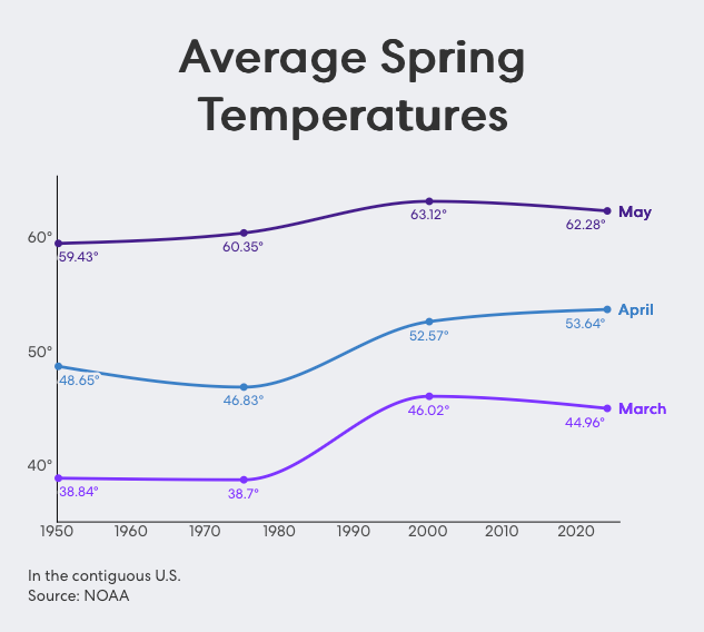
NOAA’s data paints a clear picture of warming. Since 1950, average March temperatures have increased from 38.8°F to nearly 45°F nationwide, while May temperatures are now averaging over 62°F, up from around 59.4°F in the 1950s.
These increases are more than just numbers. Warmer springs mean:
- Shorter winters and earlier snowmelt in some areas
- Longer growing seasons, which may favor invasive species and pests
- Greater energy use for air conditioning in early spring
- Changing migration patterns for birds and insects
In South Carolina, spring temperature increases are in the moderate range, but still consistent. Most of the state has seen March–May temperatures rise between 2°F and 6°F over the last 70 years, as shown in NOAA’s Spring Temperature Change map. The northern and central regions of the state are warming slightly faster than coastal areas.
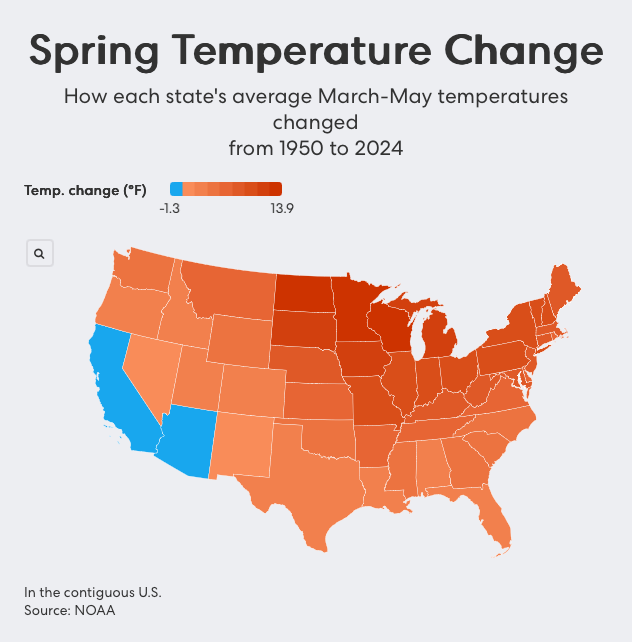
View NOAA’s interactive spring temperature graph on their climate site.
Spring is rainier too — especially in parts of the Southeast
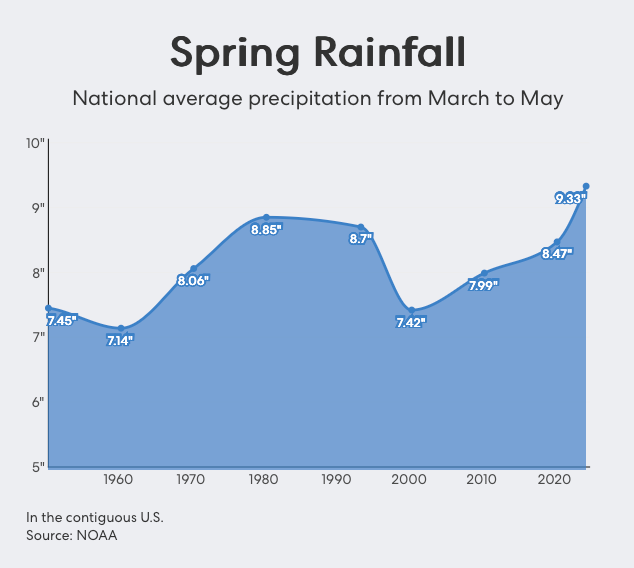
From 1950 to 2024, average spring precipitation across the U.S. increased from around 7.4 inches to over 9.3 inches, according to NOAA’s historical weather records. That’s the highest spring rainfall average ever recorded for the nation.
In the Carolinas, the impact is noticeable — but variable. A U.S. Global Change Research Program map shows that northern South Carolina and western North Carolina have experienced increased spring rainfall since the mid-20th century, while parts of coastal South Carolina have remained flat or slightly decreased in precipitation.
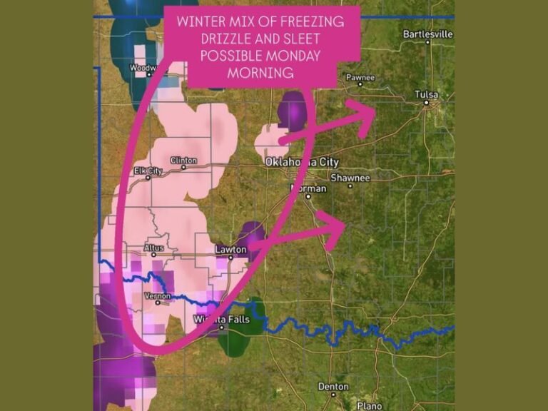
Notably, some of the most extreme flooding events in the region over the last decade have occurred during spring months — including flash flooding in Lincoln County and Horry County, as well as severe downpours that prompted flood alerts from Charlotte to Charleston.

What the changes mean for South Carolina and North Carolina residents
The effects of a warmer, earlier, and wetter spring are already being felt by people across the Carolinas in ways both obvious and hidden:
1. Public health and allergies
Earlier blooming trees and plants lead to longer and more intense pollen seasons. For people with asthma or seasonal allergies, this means symptoms begin earlier and may persist into summer.
2. Flood risk and infrastructure
Increased rainfall — especially when it arrives in short, heavy bursts — can overwhelm stormwater systems, damage roads, and threaten homes in low-lying areas. Many South Carolina cities, like Columbia and Myrtle Beach, are investing in flood-prevention infrastructure in anticipation of more severe spring rains.
3. Agricultural disruptions
Farmers across the Southeast are contending with shifting planting schedules, changing frost dates, and the need for new crop rotation strategies. Crops like peaches and strawberries, which are sensitive to bloom timing, are particularly vulnerable to these changes.
4. Wildlife and ecosystems
Animals that migrate or breed based on seasonal cues may find themselves out of sync with the food sources they depend on. For example, if insects hatch earlier due to warmth but birds haven’t migrated back yet, there’s a mismatch in the food chain.
Looking ahead: Is there any relief in sight?
NOAA’s most recent seasonal outlook for the Southeast U.S. shows continued above-average temperatures and precipitation for upcoming spring seasons. The agency also projects that climate extremes — such as flash floods and heat waves — will become more common unless greenhouse gas emissions are reduced significantly.
While climate adaptation efforts are underway in many Carolinas towns — including stormwater system upgrades, tree planting programs, and emergency planning — experts stress that long-term climate mitigation will require broader action.
What you can do locally
- Plant native trees and shrubs to support pollinators and help absorb rainfall
- Check your home’s drainage and roof systems before peak spring storms
- Support local policies that promote green infrastructure and conservation
- Stay updated with allergy forecasts and flood alerts using trusted apps or NOAA’s services
As reported by Yahoo News, these trends are already underway — and communities across the U.S. will need to prepare for more seasonal extremes in the years ahead.
Have you noticed the signs of an earlier spring — budding flowers, rising temperatures, or heavier storms? We want to hear from you. Share your stories and photos with the Saluda Standard-Sentinel team.