SPC Upgrades Wednesday Severe Risk to 30 Percent Across Missouri and Illinois With Damaging Winds Targeting Kansas City and St Louis
KANSAS CITY, MO — The Storm Prediction Center has upgraded its Wednesday, June 17, severe weather outlook to a 30% probability across Missouri, Illinois, and eastern Kansas, an unusually high risk level to see this far in advance, with forecasters indicating the most significant threat will shift west into the Lower Missouri Valley where strong storms are expected to develop and consolidate into a long line of damaging wind through the evening hours.
A Rare High-End Outlook This Far Out
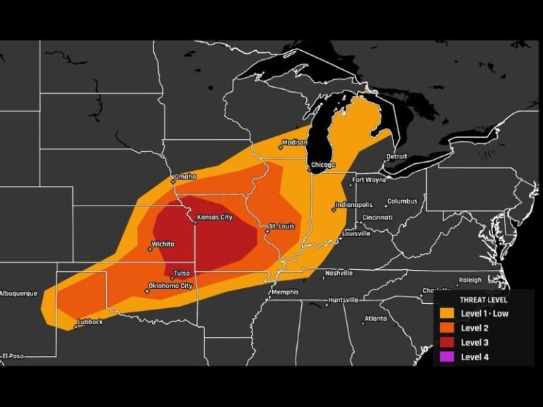
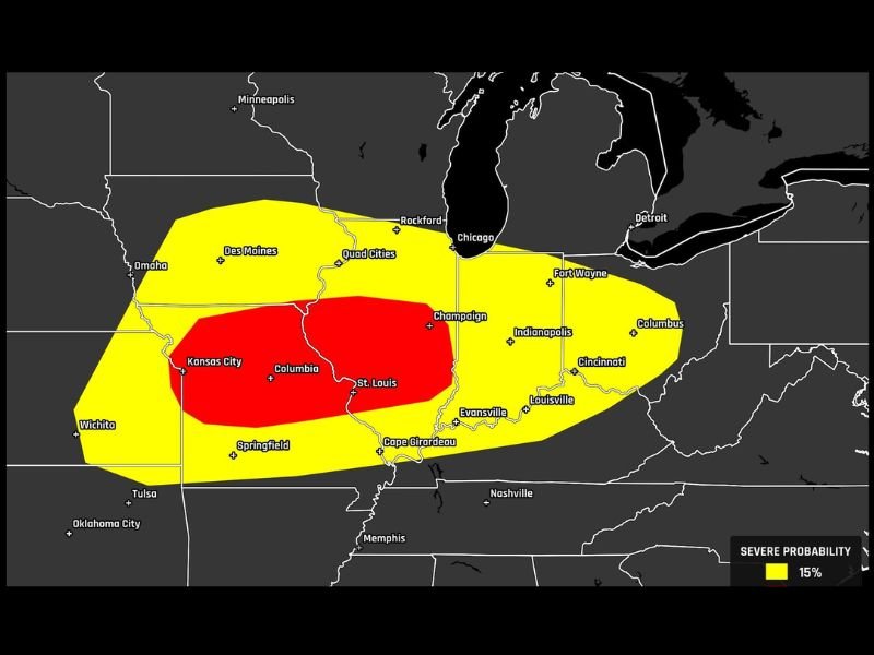
The Day 4 SPC probabilistic outlook updated June 14 at 3:57 a.m. ET depicts a 30% severe probability zone — the highest category currently shown on the map — covering a substantial area centered on Kansas City, Columbia, and St. Louis. A 30% risk at four days out is considered rare, and forecasters note this level of confidence this far in advance has drawn significant attention within the meteorological community.
The broader 15% probability zone extends outward in an elongated footprint from Des Moines and the Quad Cities through Champaign, Indianapolis, Louisville, and Cincinnati, while also reaching westward toward Wichita, Tulsa, and Oklahoma City.
How Wednesday’s Setup Evolves
The expected sequence for Wednesday begins with strong, potentially discrete storms developing first across the Lower Missouri Valley region. As the day progresses, these storms are forecast to clump together into one large, organized line capable of producing a long swath of damaging wind extending into the evening hours.
This evolution — from discrete strong storms to a consolidated damaging wind-producing line — is a pattern capable of impacting a very large geographic area in a relatively short window once the line becomes organized and begins its eastward progression.
Continued Refinement Expected
Forecasters caution that with the event still several days away, the exact placement of the highest-risk zone retains room to shift. The overall trend in confidence has been increasing, however, with the upgrade from the previous outlook reflecting growing model agreement on a significant severe weather event for the Lower Missouri Valley and surrounding region.
Residents across Missouri, Illinois, and eastern Kansas should begin monitoring forecasts closely as Wednesday approaches and confidence in placement increases. For continuing coverage of this developing severe weather outlook across the United States, visit SaludaStandard-Sentinel.com.