Pennsylvania Braces for Two-Part Winter Weather Threat as Weak Snow System Friday Night Is Followed by Possible Coastal Snow This Weekend
PENNSYLVANIA — A developing winter weather pattern is expected to bring two separate rounds of snow across Pennsylvania this weekend, beginning Friday evening and potentially extending into Sunday afternoon, according to the latest regional forecast analysis.
While neither system is expected to produce a major snowstorm, cold surface temperatures and repeated light snowfall could still create travel issues, especially on untreated roads, highways, and interstates across large portions of the state.
First Winter Disturbance Moves In Friday Evening
The first weak disturbance is forecast to move into Pennsylvania Friday evening, continuing through Saturday daytime hours. This initial system has trended slightly drier over the last 24 hours, but meteorologists caution that even limited snowfall could still cause impacts due to cold ground conditions.
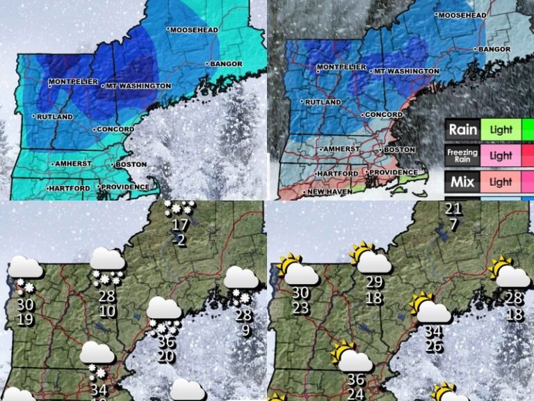
Western and north-central portions of Pennsylvania are expected to see light but measurable snow, with most areas picking up around 1 inch, and localized totals approaching 2 inches in some locations.
Despite modest snowfall amounts, roadway conditions could deteriorate quickly, particularly during overnight and early morning hours when temperatures remain below freezing.
Downsloping Limits Snow in Central Pennsylvania
Across central Pennsylvania, atmospheric downsloping is expected to reduce moisture availability, allowing the air mass to “dry out” as it moves eastward. This setup will likely result in intermittent snowflakes or very light accumulations, with some areas seeing little more than flurries.
Communities in the central corridor should still remain cautious, as even light snow combined with cold pavement can create slick driving conditions, particularly on secondary roads.
Eastern Pennsylvania Could See Higher Snow Potential
Far eastern Pennsylvania remains a zone of closer monitoring during the first system. Increased moisture off the Atlantic Ocean may allow for a secondary snow maximum, with slightly higher accumulations than central areas.
While totals are still expected to remain on the lighter side, persistent snowfall could lead to localized travel slowdowns, especially during Saturday.
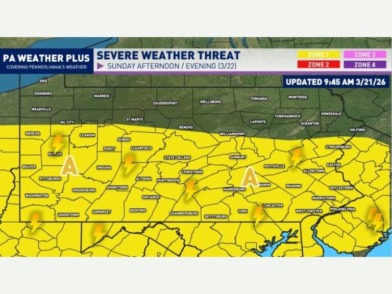
Second System May Bring Additional Snow Saturday Night Into Sunday
Meteorologists are also tracking a second, separate weather system that could affect Pennsylvania Saturday night through Sunday afternoon, particularly across the eastern half of the state.
This system’s impact will depend heavily on how far west a weak coastal low pressure system tracks. While it is not expected to become a strong storm, another round of light accumulating snow remains possible.
If the coastal low tracks closer to shore, eastern Pennsylvania could see additional snow accumulation, along with poor road conditions continuing into Sunday.
What Residents Should Expect
- Light snow Friday night into Saturday
- Greatest accumulation potential in western and eastern Pennsylvania
- Central areas mainly flurries or light snow
- Possible second round of snow Saturday night into Sunday
- Ongoing slick roads despite low totals
Meteorologists stress that even weak systems can cause outsized impacts when temperatures remain cold and snowfall occurs in multiple rounds.
Stay Alert as Forecasts Continue to Evolve
Forecasters will continue monitoring how both systems evolve, especially the track of the potential coastal low later in the weekend. Small changes could shift snowfall amounts or impact areas farther west than currently expected.
Residents are encouraged to stay tuned for updates, plan ahead for weekend travel, and allow extra time if driving during periods of snow.
For continuing weather coverage, updates, and regional forecasts, visit SaludaStandard-Sentinel.com and stay informed as conditions change.