North Carolina Weather Turns Milder Midweek Before Cooler Air Returns and a Possible Weekend System Emerges
NORTH CAROLINA — Weather headlines are shifting across the state this week, with a brief but noticeable warm-up arriving midweek before cooler air returns and attention turns toward a potential storm system next weekend. While forecast models continue to generate discussion, forecasters stress that confidence remains highest in temperature trends, not storm specifics.
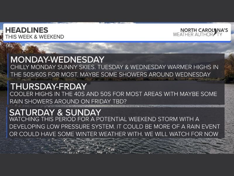
Monday Brings Sunshine With Seasonable Chilly Temperatures
Monday will feature partly to mostly sunny skies statewide, with daytime highs reaching the 30s and 40s. While it remains cool, conditions will be calm and dry, offering a quiet start to the week.
Tuesday Delivers the Warmest Day in Weeks Across the State
Tuesday is expected to be the warmest day North Carolina has seen in several weeks, as warmer air surges into the region. High temperatures are forecast to reach the 50s and 60s for most areas, accompanied by partly sunny skies. This brief warm-up will provide a noticeable break from winter-like conditions and may feel almost springlike in some communities.
Wednesday Stays Mild but Clouds and Showers Increase
Temperatures remain elevated on Wednesday, with highs in the 40s and 50s, and some locations still reaching the 60s. However, cloud cover will increase through the day, and scattered rain showers are expected to develop. Rain coverage is not expected to be widespread or severe, but outdoor plans may be impacted at times.
Cooler and Quieter Weather Returns Thursday and Friday
By Thursday, the pattern shifts again as cooler air settles back into the region. Highs will generally range from the 40s to low 50s, with quieter weather conditions overall.
Friday looks similar, with cool temperatures in the 40s for many areas. There is still some uncertainty regarding scattered rain showers, but any rainfall appears limited at this time.
Next Weekend System Shows Rain Signal, Winter Weather Still Uncertain
Attention is increasingly turning toward next weekend, where forecast models show decent support for a developing low-pressure system. At this point, most data favors a soaking rain event somewhere in the region rather than a significant winter storm.
A few models still hint at some winter weather potential, but forecasters emphasize that there is currently nothing to be concerned about, and confidence remains low this far out. Officials caution against hype, noting that model volatility is common several days in advance.
Forecast Confidence Remains Focused on Trends, Not Hype
Meteorologists stress that responsible forecasting requires patience, especially with long-range model guidance. While scenarios can change, the most likely outcome at this time is a rain-dominant system next weekend, not a major winter event.
Updates will continue as clarity improves over the coming days. For continued weather coverage and updates across the Carolinas, follow SaludaStandard-Sentinel.com.