NOAA Forecast Warns of Below-Normal Temperatures for Louisiana, Mississippi, Arkansas, Tennessee, Missouri, Georgia, the Carolinas, and Most of Florida
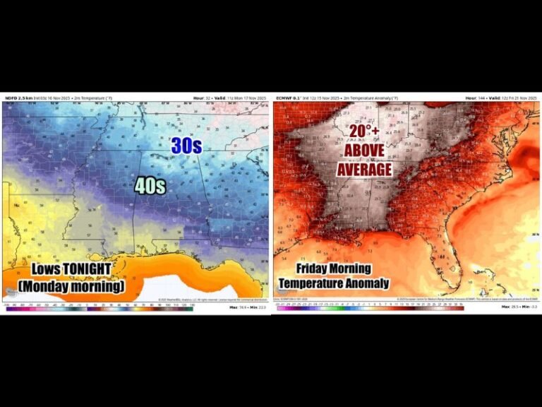
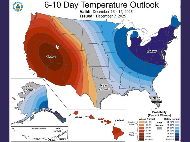
SOUTHEASTERN UNITED STATES — A new NOAA 6–10 Day Temperature Outlook is putting much of the Southeast on alert, with Louisiana, Mississippi, Arkansas, Tennessee, Missouri, Georgia, the Carolinas, and most of Florida all expected to experience below-normal temperatures between December 13 and 17, 2025.
The updated map highlights a strong push of colder-than-average air across the region, signaling an early-season pattern shift that residents will feel quickly.
Widespread Southeast Cold Expected
According to NOAA, below-normal temperatures dominate nearly the entire Southeast. States likely to see the most persistent chill include:
- Louisiana & Mississippi: Forecast to run below normal, with cold strong enough to “make your bones file a complaint,” as social reactions put it.
- Arkansas, Tennessee & Missouri: A broad zone of colder-than-average air extending into the mid-South, reinforcing a multi-day cold trend.
- Georgia & the Carolinas: Also firmly in the below-normal category, matching a regional cooling pattern that invites everyone to the “cold front family reunion.”
- Florida: Most of the state falls below normal, except far South Florida, which once again appears likely to dodge the chill and cling to warm beach-like conditions.
West Texas Breaks the Trend
One major outlier appears across West Texas, which is projected to run above normal, standing in sharp contrast to the cooling across the Southeast and mid-South. NOAA’s map shows a strong warm plume developing across the Southwest and Southern Plains, putting Texas on the warm side of the national divide.
Meteorologists Note Possible Westward Shift
Some forecasters suggest the cold anomaly could expand farther west in upcoming updates, depending on how the jet stream evolves. NOAA’s probability map is already showing a large, well-organized cold pool centered over the Midwest, dipping deep into the Southeast.
Residents Should Expect Quick Weather App Changes
NOAA’s long-range tools often update rapidly, meaning digital weather apps may shift suddenly in the coming days. Residents across the Southeast should stay alert for colder morning lows, increased frost potential, and the possibility of stronger cold fronts sweeping through mid-month.
Bottom Line
The new NOAA outlook signals a significant temperature drop for much of the Southeast and mid-South, affecting Louisiana, Mississippi, Arkansas, Tennessee, Missouri, Georgia, North Carolina, South Carolina, and most of Florida. With winter patterns strengthening, residents should prepare for noticeably colder days and nights heading into the second week of December.
For continuing updates on temperature trends, cold air intrusions, and regional weather impacts, stay connected with SaludaStandard-Sentinel.com.