Multiple Rounds of Heavy Rain and Storms Return to the Gulf Coast Tomorrow Afternoon Into Evening as Second Wave of Wet Weather Targets Louisiana Mississippi and Alabama Corridor
GULF COAST REGION — A second round of rain and thunderstorms is set to push back into the Gulf Coast region tomorrow afternoon and continuing into the evening hours, bringing multiple rounds of rainfall with pockets of heavy precipitation possible across Louisiana, Mississippi, and Alabama as the moisture-laden system returns to an area that has already seen significant rainfall in recent days.
Second Round of Storms Arriving Tomorrow Afternoon
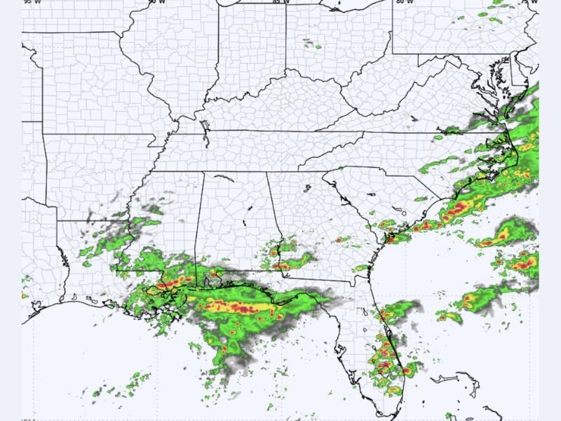
Radar imagery shows active precipitation already organized along the Gulf Coast from Louisiana through coastal Mississippi and Alabama, with the storm system forecast to intensify and expand coverage during the afternoon and evening hours tomorrow. The return of rainfall to this corridor represents a second significant wet weather episode for communities that received heavy rain during the previous round, raising concerns about additional accumulation on already saturated ground across the affected parishes and counties.
The afternoon timing of the storm return means conditions could deteriorate rapidly during peak activity hours across the Gulf Coast region.
Pockets of Heavy Rainfall the Primary Concern
While the overall severe weather threat associated with tomorrow’s storm round remains limited, pockets of heavy rainfall embedded within the broader precipitation shield represent the most significant hazard for Gulf Coast communities during the afternoon and evening period. Heavy rainfall rates occurring over short timeframes can overwhelm drainage systems, generate rapid water rises across low-lying roadways, and contribute to localized flash flooding across areas with saturated soil conditions from previous rainfall events.
Residents across coastal Louisiana, Mississippi, and Alabama are urged to remain aware of any flash flood advisories or warnings that may be issued as the heavier rainfall pockets move through the region tomorrow.
Additional Storm Activity Along the Southeast Atlantic Coast
Beyond the Gulf Coast, radar imagery shows additional shower and storm activity developing along the Southeast Atlantic coastal corridor, indicating that the broader moisture pattern affecting the region extends well beyond the immediate Gulf Coast zone. Communities across coastal Georgia, South Carolina, and into the mid-Atlantic are experiencing scattered shower activity simultaneously with the Gulf Coast rainfall, reflecting the expansive geographic reach of the current wet weather pattern across the southeastern United States.
Residents across all affected coastal communities should monitor local forecasts through tomorrow afternoon and keep weather alert systems active as the second round of storms pushes through the region.
For continuing coverage of severe weather events and critical storm analysis across the United States, visit SaludaStandard-Sentinel.com.