Major Midwest Winter Storm to Blanket Illinois, Iowa, and Michigan with 8–14 Inches of Snow This Weekend
CHICAGO, ILLINOIS — A powerful winter storm system is set to sweep across the Midwest and Great Lakes this weekend, bringing heavy snow totals, strong winds, and whiteout conditions to millions from Iowa to Michigan.
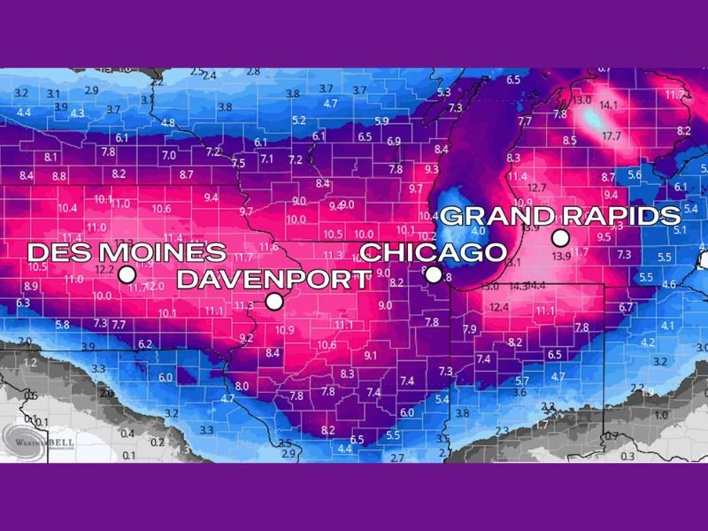
Forecast models from WeatherBell Analytics show widespread snowfall ranging between 8 to 14 inches, with localized totals possibly exceeding 15 inches in some areas. The storm is expected to develop Friday night and intensify through Saturday and Sunday, creating dangerous travel conditions across several states.
Heavy Snowfall Expected Across Multiple States
Meteorologists warn that this will be the most significant snowfall event of the season so far, impacting parts of Iowa, Illinois, Wisconsin, Indiana, and Michigan.
Cities currently in the storm’s heaviest snow corridor include:
- Des Moines, Iowa: 10–12 inches expected
- Davenport, Iowa: 11 inches possible
- Chicago, Illinois: 8–10 inches expected
- Grand Rapids, Michigan: 13–14 inches likely
The National Weather Service (NWS) has issued winter storm watches and advisories for much of the central Midwest, warning that heavy, blowing snow could reduce visibility to near zero at times.
“This system will deliver double-digit snowfall totals and blizzard-like conditions for some areas,” forecasters said Friday morning. “Travel will be treacherous through the weekend, especially on interstates I-80, I-90, and I-94.”
Blizzard-Like Conditions Possible
Strong winds accompanying the snow will make conditions even more hazardous. Gusts between 30 and 40 mph could produce whiteout conditions, making travel nearly impossible at times — particularly in open rural areas of Iowa and northern Illinois.
Forecasters expect the heaviest snowfall to occur Saturday afternoon through early Sunday morning, with snow rates possibly reaching 1 to 2 inches per hour in parts of eastern Iowa and northern Illinois.
“Once this snow starts falling, it will accumulate quickly,” warned meteorologists in Chicago. “Wind gusts will make it blow and drift, so even cleared roads could be covered again within minutes.”
Travel Impacts and Safety Concerns
The combination of heavy snow and strong winds will likely lead to flight delays, road closures, and power outages across the affected states.
Airports in Chicago, Des Moines, and Grand Rapids are preparing for cancellations and delays, while highway officials are urging residents to avoid unnecessary travel during the height of the storm.
Drivers who must travel should:
- Carry winter emergency kits, including blankets, flashlights, and food.
- Keep fuel tanks at least half full to prevent freezing.
- Slow down and maintain extra space between vehicles.
- Avoid traveling at night if possible.
Authorities emphasize that blowing snow will likely continue even after accumulation ends, prolonging hazards into Sunday afternoon.
Cold Air and Lingering Impacts
Behind the storm, temperatures are expected to plunge into the teens and single digits, ensuring that snowpack remains through early next week. Wind chills could dip below zero in parts of northern Illinois, Iowa, and southern Wisconsin by Monday morning.
Residents across the region are advised to clear sidewalks and driveways gradually to prevent ice buildup and to check on elderly or vulnerable neighbors.
Outlook
Meteorologists expect conditions to slowly improve Sunday night as the storm exits into the Great Lakes and moves toward the Northeast. However, lake-effect snow bands could linger over western Michigan through Monday, bringing additional accumulation to areas around Grand Rapids and Kalamazoo.
“This storm is a reminder that winter is arriving in full force,” one forecaster said. “Prepare now, because travel will be extremely difficult or impossible for much of the weekend.”
Stay tuned to SaludaStandard-Sentinel.com for the latest weather alerts, travel updates, and post-storm coverage across the Midwest and Great Lakes.