Long-Range Forecast Shows Repeated Cold Surges and Snow Chances for Illinois, Ohio, Pennsylvania, New York, and the Upper Midwest as Winter Pattern Reloads Through Mid-December
UNITED STATES — A long-duration winter pattern is expected to reload repeatedly over the next 10 days, bringing fresh cold surges and renewed snow chances across Illinois, Ohio, Pennsylvania, New York, Wisconsin, Minnesota, and the broader Upper Midwest. Forecast signals show strong consistency, indicating that temperatures may remain well below normal for many northern and eastern states through mid-December.
Cold Pattern Expected to Reload Several Times Through December 16
Forecast trends highlight a persistent setup in which Arctic air masses continue dropping southward into the Midwest and Northeast. This pattern supports a series of reinforcing cold fronts, keeping temperatures suppressed and limiting opportunities for warm-ups.
Model data suggests an 80% probability of below-normal temperatures across large portions of the Midwest and Great Lakes, including Chicago, Cleveland, Detroit, Buffalo, and Pittsburgh. The cold pattern may only feature brief breaks before the next surge arrives.
The western United States shows the opposite extreme, with 90% above-normal temperature probabilities across states like California, Nevada, and Arizona, creating a stark coast-to-coast contrast.
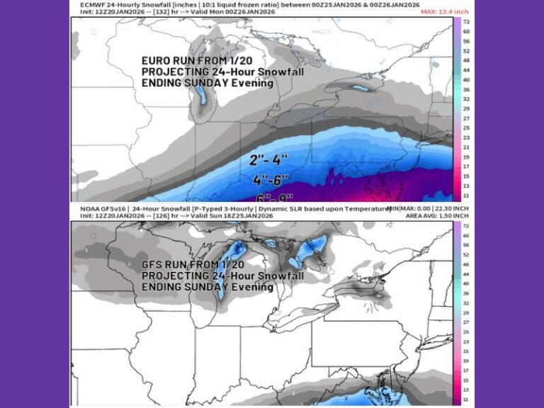
Active Clipper Systems Could Bring Repeated Snow Chances
Meteorologists expect a steady parade of Alberta clipper systems riding along the jet stream, bringing opportunities for light to moderate snowfall across the Upper Midwest, Great Lakes, and into the interior Northeast. These fast-moving systems, combined with the persistent cold air base, may contribute to frequent snow events for cities such as Minneapolis, Milwaukee, Chicago, Grand Rapids, and Cleveland.
The map highlights a Favored Snow Zone extending from the northern Rockies through the Midwest and into the Great Lakes region. This corridor is expected to remain active, with clippers delivering small but frequent accumulations over the next week and beyond.
Eastern U.S. Could See Continued Cold Into Late December
Some long-range signals suggest that this reloading winter pattern may extend beyond the next 10 days, especially for Ohio, Pennsylvania, New York, and the Appalachian region. Although long-range forecasts carry uncertainty, the consistency of the cold signal increases the likelihood of a prolonged chill.
Cold-sensitive infrastructure, agriculture, and transportation sectors should monitor updates closely as repeated cold surges and snow chances evolve.
Are you already noticing the early impacts of this reloading winter pattern? Share your updates and follow continuing coverage at SaludaStandard-Sentinel.com.