Increasing Winter Storm Potential for North Carolina, South Carolina, and Virginia as Model Trends Strengthen Late-Week Signal
NORTH CAROLINA — Weather forecasters are closely monitoring a developing winter weather pattern that could impact parts of North Carolina, South Carolina, and Virginia later this weekend, though confidence remains limited several days out and key details are still evolving.
Why Meteorologists Are Paying Close Attention
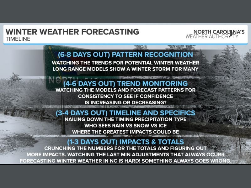
At least five to six days remain before any potential winter weather, placing this forecast firmly in the pattern recognition and trend-monitoring phase. During this stage, meteorologists focus on whether multiple long-range models consistently show a similar setup — not exact snowfall totals or impact zones.
Recent model trends have shown increasing agreement on a colder pattern moving into the Southeast, which raises the possibility of wintry precipitation. However, forecasters stress that significant changes are still possible, especially in the Carolinas where small temperature shifts can drastically alter outcomes.
Areas Currently Showing the Strongest Signal
Based on the available data, the core region being monitored is limited to North Carolina, South Carolina, and Virginia.
At this time, there is no reliable evidence supporting winter storm impacts for Texas, Oklahoma, Arkansas, Louisiana, Mississippi, Alabama, or Georgia within this specific forecast discussion. Any claims extending impacts into those states would be premature and unsupported by current data.
Potential Weather Types Still Uncertain
As of now, all precipitation types remain on the table, including rain, freezing rain, sleet, and snow. The presence of colder air later this weekend appears likely, but the exact placement of freezing temperatures — which determines precipitation type — cannot yet be resolved.
Forecasters emphasize that this does not mean a major storm is guaranteed, only that the risk window is opening and warrants careful monitoring.
Why Confidence Will Increase Later
Forecast confidence typically improves within the three- to four-day timeframe, when higher-resolution models better resolve temperature profiles, storm tracks, and timing. This upcoming period will be critical for determining whether impacts remain minimal or become more disruptive.
Meteorologists caution against reacting to isolated or extreme model runs, noting that winter weather forecasting in the Carolinas is particularly prone to last-minute changes.
What Residents Should Do Right Now
At this stage, awareness is more important than action. Residents are encouraged to stay informed, monitor forecasts from reliable local sources, and avoid unnecessary alarm while trends continue to develop.
More definitive guidance is expected within the next 24 to 72 hours, as meteorologists refine timing, precipitation type, and potential impacts.
As always, SaludaStandard-Sentinel.com will continue providing clear, responsible updates as confidence increases and new data becomes available.