Illinois to See Spring-Like 60° Warmth Early Next Week Before Late-Week Storm System Brings Uncertain Rain or Wintry Mix
ILLINOIS — A burst of spring-like warmth is set to take over much of the Midwest early next week, with temperatures climbing into the upper 50s and lower 60s as a strong upper-level ridge builds across the central United States. But forecasters caution that the mild stretch may be short-lived, with a developing system later in the week bringing the potential for more active weather.
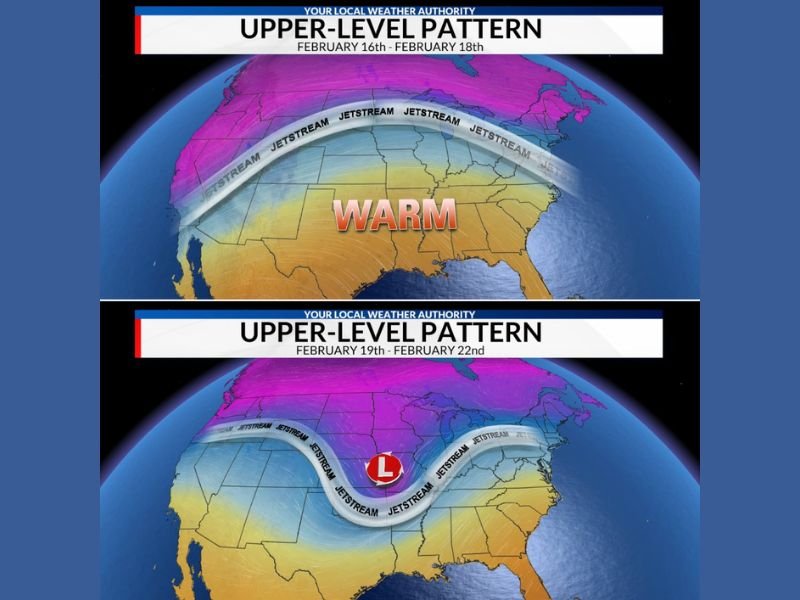
Meteorologists say the early-week warmup is being driven by a pronounced ridge in the upper atmosphere, allowing milder air to expand northward. The jet stream is positioned well to the north during this period, helping lock in above-normal temperatures across Illinois and neighboring states.
For mid-February, highs in the 58° to 62° range are several degrees above seasonal averages. The warmer air will provide a noticeable break from winter chill and could give communities a brief taste of early spring.
Pattern Change Late Week
However, forecast models show a shift beginning around the middle to latter part of the week. The upper-level pattern appears to transition from a ridge (associated with warmth) to a trough and developing low-pressure system across the central U.S.
This shift will open the door for precipitation chances to return.
The exact track and strength of the system remain uncertain. Current projections suggest a wide range of possibilities, including:
- Rain
- Thunderstorms
- Wintry precipitation, depending on temperature profiles and storm path
Forecasters emphasize that while details are still evolving, the pattern does look more supportive of meaningful precipitation compared to recent dry stretches.
Why This Matters
Parts of the Midwest have been relatively dry, and any organized precipitation could help improve soil moisture levels. That said, if colder air wraps into the system at the right time, some areas could briefly see a transition to wintry conditions.
Model guidance currently varies, and meteorologists note that it is too early to pinpoint exact precipitation types or totals. What is clearer is that the calm, warm pattern early in the week will not hold through the weekend.
Enjoy the Warmth — Winter Isn’t Done Yet
Despite the temporary warm spell, forecasters remind residents that it is still February. Large temperature swings are common this time of year, and winter weather can quickly return if the jet stream dips southward again.
For now, residents can expect comfortable afternoons early next week before attention turns to the developing late-week system and its potential impacts. Stay updated on changing conditions and evolving forecasts by visiting SaludaStandard-Sentinel.com for the latest regional weather coverage and analysis.