Illinois Braces for Severe Storms Tuesday Evening as Warm Front Lifts North With Tornado, Hail and Damaging Wind Threat
ILLINOIS — Meteorologists are closely watching a developing severe weather setup across Illinois on Tuesday, March 10, 2026, as a warm front lifts into the region and creates favorable conditions for powerful thunderstorms.
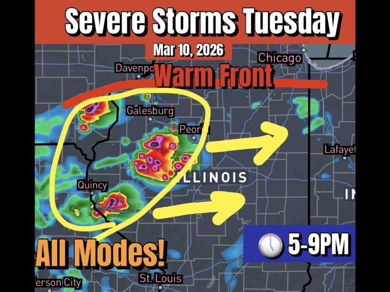
Forecast models suggest that storms could begin intensifying during the late afternoon and evening hours, with the primary window for severe weather expected between 5 p.m. and 9 p.m.
Forecasters say the environment may support multiple types of severe weather, including damaging winds, large hail, and even the possibility of a tornado if storms become organized.
Warm Front Could Trigger Explosive Storm Development
The approaching warm front is expected to push northward across Illinois Tuesday, helping pull warm, moisture-rich air into the region.
At the same time, strong wind shear in the atmosphere could help storms rotate, creating conditions supportive of supercell thunderstorms capable of producing severe weather.
Meteorologists say this combination of moisture, instability, and wind shear could allow storms to quickly intensify as they track eastward across the state.
Areas across western and central Illinois — including regions near Quincy, Galesburg, and Peoria — may be among the first to see storms develop before the system potentially pushes farther east.
Tornado Risk Cannot Be Ruled Out
While the overall storm evolution remains uncertain, forecasters say all modes of severe weather appear possible with Tuesday’s storms.
That includes the potential for:
- Damaging wind gusts
- Large hail
- Isolated tornadoes
Meteorologists note that if storms remain discrete supercells rather than forming into a large cluster, the tornado risk could increase.
However, one complicating factor may be cool air from Lake Michigan, which could push southward and temporarily slow or disrupt the northward movement of the warm front. If the front stalls, storm intensity could vary depending on exactly where the warm and cool air masses collide.
Evening Storm Window Could Bring Strongest Impacts
Current model guidance suggests that the late afternoon through early evening hours may bring the greatest severe weather potential.
Storms developing in western Illinois could strengthen quickly as they track eastward across the state. Residents across central and northern Illinois — including communities closer to Chicago — may see storms later in the evening depending on how the system evolves.
Residents Urged to Monitor Forecast Updates
Because the setup depends heavily on the exact placement of the warm front and local atmospheric conditions, meteorologists say forecast details could still change as Tuesday approaches. Residents across Illinois are encouraged to stay weather aware and monitor alerts throughout the day if storms begin developing.
Having multiple ways to receive weather warnings and a safety plan in place is especially important during severe weather events. Stay with SaludaStandard-Sentinel.com for continued coverage and updates as meteorologists track this developing severe weather threat across the Midwest.