Heavy Rainfall Expected Across Texas, Oklahoma, Arkansas and Surrounding States as Active Weather Pattern Develops Through Thanksgiving Week
TEXAS – A developing storm pattern will bring rounds of heavy rain across the south-central United States this week and into Thanksgiving week, with several inches of rainfall forecast from Texas and Oklahoma into Arkansas, Louisiana, Mississippi, Tennessee, Kansas and Missouri. Forecasters warn that flooding and isolated severe weather will be possible as widespread precipitation spreads across the region.
Widespread Rainfall Expected Across Multiple States
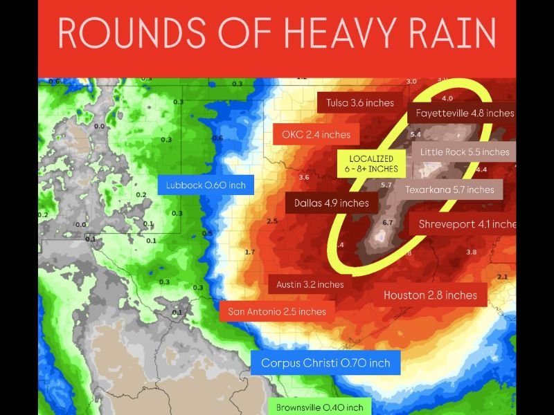
Meteorologists expect a sustained window of moisture over the next week and a half, with a few to several inches of rain falling across multiple states. Current projections show:
Dallas around 4.9 inches
Tulsa around 3.6 inches
Oklahoma City around 2.4 inches
Austin around 3.2 inches
San Antonio around 2.5 inches
Texarkana around 5.7 inches
Shreveport around 4.1 inches
Fayetteville around 4.8 inches
Little Rock around 5.5 inches
Localized zones reaching 6–8 inches
This rainfall is expected to stretch from the southern Plains through the Mississippi Valley as the pattern strengthens heading into the holiday period.
Areas Facing Highest Flooding Risk
The region highlighted for the heaviest rainfall totals, including areas of Arkansas, eastern Oklahoma, northern Louisiana, and portions of Missouri, could see 6 to 8 inches in localized pockets. Meteorologists say these areas may face elevated flood risks due to repeated rounds of thunderstorms and slow-moving moisture bands.
Urban areas across Texas and Oklahoma, particularly Dallas and Houston, may also see short-term flooding, especially near low-lying roads and drainage zones.
Ongoing Drought Conditions Make Rainfall Critical
While the threat of flooding remains, the incoming rainfall is also desperately needed, as portions of Texas, Oklahoma, and Arkansas continue experiencing intensifying drought conditions. Many counties have seen below-normal rainfall for months, and soil moisture remains severely limited.
Forecasters note that while this system will not end the drought, receiving several inches of rain over the next ten days will be beneficial for reservoirs, agriculture, and wildfire risk reduction.
Thanksgiving Week Could Bring Additional Severe Weather
The active weather pattern is expected to continue into Thanksgiving week, meaning additional rain and potential severe weather episodes cannot be ruled out. Thunderstorms, strong winds, and even isolated hail are possible depending on how the system evolves.
Residents across the south-central U.S. are encouraged to monitor daily forecasts as the pattern takes shape, especially in areas prone to flash flooding.
If you live in one of the affected states, how are you preparing for the heavy rainfall? Share your thoughts and stay updated with SaludaStandard-Sentinel.com for continuing coverage.