Georgia and Gulf Coast States Brace for Powerful Winds Thursday and Friday as Cold Front Sweeps Through
GEORGIA — A powerful cold front is set to deliver strong, potentially damaging winds across Georgia, Alabama, and the Gulf Coast region on Thursday and Friday, with forecasters warning residents to secure loose objects and prepare for sudden gusts capable of causing travel disruptions and property damage.
According to weather models, the system will sweep southeastward with sustained winds between 25–35 mph and gusts reaching 45–55 mph in some areas. The National Weather Service reports that colder air behind the front will also bring a sharp temperature drop, leading to chilly conditions across much of the Southeast by Friday morning.
Atlanta and Surrounding Areas to Face Intense Gusts
Meteorologists say Atlanta will be directly in the path of Thursday’s wind surge, with gusts strong enough to topple lightweight structures, blow unsecured decorations, and down small tree limbs.
“This isn’t your average windy day — these gusts have intent,” one Atlanta-based forecaster joked. “People will be holding onto wigs, hats, and patience because this wind is about to make itself known.”
Forecast maps show wind chills dipping into the 20s, with sustained gusts moving eastward across central and southern Georgia and into the Carolinas by early Friday.
Gulf Coast Also in the Crosshairs
The same storm front will impact areas along the Gulf Coast, including Mobile, Pensacola, and New Orleans, bringing strong westerly winds and scattered showers.
Forecasters expect temperatures to fall rapidly overnight, with lows in the upper 20s and low 30s by Friday morning.
Gulf Coast residents could see inflatables, porch furniture, and trash bins blown into streets by the gusty conditions. Local agencies have urged people to secure outdoor items and avoid unnecessary travel during peak wind hours.
“These winds are strong enough to turn a yard decoration into a flying object,” warned a National Weather Service statement. “Take precautions now, especially for those living near open areas or coastal zones.”
Cold Front Brings Sharp Temperature Drop
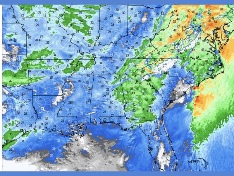
The storm system marks the leading edge of a major cold front sweeping through the eastern U.S. Temperatures behind it are expected to plummet by 15–25 degrees compared to Wednesday.
Friday morning wind chills could reach the teens and 20s in northern Alabama and Georgia, while coastal regions remain in the 30s.
Weather maps show cold air stretching from eastern Texas through the Carolinas, reinforcing the dramatic transition from mild to winter-like conditions in less than 24 hours.
Safety and Travel Precautions
Forecasters advise residents across Georgia, Alabama, and the Gulf Coast to prepare for:
- Flying debris and unstable decorations
- Difficult driving conditions, especially for high-profile vehicles
- Possible spotty power outages due to fallen branches
Residents are urged to avoid outdoor activities during the strongest gusts and ensure their wigs, hats, and holiday décor are secured before the front arrives.
Looking Ahead
By late Friday, winds are expected to gradually weaken as the high-pressure system moves in behind the front, leaving behind a cold, dry weekend across the region.
However, temperatures will remain well below normal, with highs struggling to reach the 40s in northern Georgia and Alabama through Saturday.
Stay updated on regional wind advisories and forecast alerts at SaludaStandard-Sentinel.com.