Colorado and Wyoming Wind Event: Mountain Wave Winds Near 50 MPH Slam Front Range Before Weekend Cold Front and Snow
COLORADO — Powerful winds have been blasting across parts of Colorado and southeastern Wyoming as a classic mountain wave wind event develops along the Front Range, producing sustained winds approaching 50 mph in some areas. Weather data from regional observation stations shows particularly strong winds impacting the northern Front Range and nearby plains, with some communities experiencing persistent gusty conditions for hours.
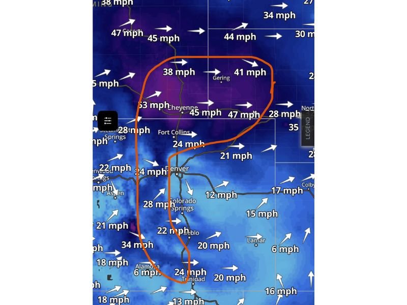
Meteorologists say the strongest winds are currently focused along the Laramie Range and Medicine Bow Mountains of southeastern Wyoming, where terrain-driven airflow is accelerating winds toward the Colorado border.
Mountain Wave Event Drives Strong Winds Across the Front Range
Weather experts describe the event as a textbook mountain wave wind pattern, a phenomenon that occurs when strong air currents flow over mountain ranges and accelerate on the downwind side.
In this case, the strongest wind energy has been directed toward northern Colorado and southeastern Wyoming. Areas near Cheyenne, Gering, and the surrounding plains have reported sustained winds between 38 and 47 mph, while nearby stations have recorded speeds exceeding 45 mph.
These winds are not just short bursts but sustained speeds measured across multiple observation stations, meaning conditions have remained consistently windy across much of the region. Interestingly, communities south of the Interstate 70 corridor have experienced noticeably calmer conditions, highlighting how terrain and atmospheric flow patterns can concentrate wind energy in specific regions.
Northern Colorado and Wyoming See Strongest Wind Speeds
Wind maps show the strongest sustained winds stretching from southeastern Wyoming into northern Colorado. Locations near Cheyenne have reported winds around 45 mph, while surrounding areas have seen readings between 38 and 47 mph.
Further south toward Denver, Colorado Springs, and Pueblo, wind speeds have generally remained lower, typically ranging between 20 and 30 mph. However, meteorologists say that even moderate winds in these areas can still cause blowing dust, difficult driving conditions, and increased fire weather concerns in dry regions.
Winds Expected to Continue Overnight and Into Friday
While the strongest winds may slowly weaken later tonight, forecasters say the mountain wave pattern could persist through the overnight hours and into Friday.
Areas inside the most intense wind corridor — particularly northern Colorado and southeastern Wyoming — may continue experiencing gusty conditions well after sunset. This means residents in these regions could wake up Friday morning to continued windy weather. Even if winds temporarily decrease overnight, meteorologists warn that they could quickly return again Friday across the Front Range and nearby plains.
Blustery Conditions Could Continue Into Saturday
Forecast projections suggest that windy weather may remain a factor into Saturday across portions of Colorado and Wyoming. Although winds may not reach the same peak intensity seen earlier in the event, breezy conditions are likely to persist as the atmosphere remains unsettled across the region. Strong winds along mountain corridors and open plains can create hazardous travel conditions, especially for high-profile vehicles traveling along Interstate highways.
Dramatic Weather Change Expected With Weekend Cold Front
Beyond the wind event, meteorologists are also watching a powerful cold front expected to sweep through the region late Saturday night.
This front could bring a dramatic shift in weather conditions, with temperatures plunging from 70-degree warmth Saturday afternoon to near the 30s by Sunday. In some areas, the colder air could even produce snowfall following the frontal passage. This rapid transition from warm temperatures to potential winter weather highlights the volatile nature of early spring weather across the Rocky Mountain region.
Residents across Colorado, Wyoming, and surrounding states are encouraged to monitor updated forecasts as the windy conditions continue and the weekend cold front approaches. Readers experiencing strong winds or changing weather conditions across the region can share their observations and updates with the community by visiting SaludaStandard-Sentinel.com.