Southern California Faces Flooding Risk as Atmospheric River Drenches Region Through the Weekend
LOS ANGELES, Calif. — Meteorologists are warning that a powerful atmospheric river is parked over Southern California, funneling a steady stream of Pacific moisture into the region and bringing the potential for flooding, mudslides, and severe weather through the weekend.
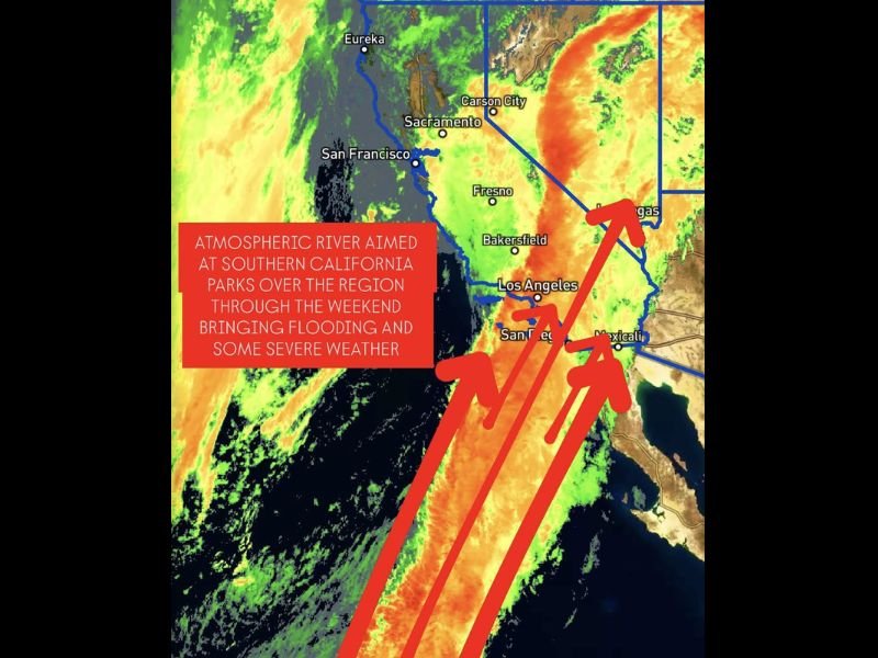
Satellite imagery from Friday morning showed a thick band of moisture extending from the central Pacific Ocean directly into Los Angeles, San Diego, and parts of the Central Valley, creating a setup for continuous rain and unsettled conditions that could last several days.
What Is Happening Over California
An atmospheric river — often described as a “river in the sky” — is a narrow corridor of concentrated moisture that can transport vast amounts of water vapor across thousands of miles. When it reaches land, especially along coastal and mountainous terrain, it can produce torrential rainfall and flash flooding.
This latest event is anchored firmly over Southern California, with models showing it will remain nearly stationary through Sunday. Forecasters say the system will drop several inches of rain across the region, particularly from Santa Barbara down through Los Angeles and San Diego Counties.
According to early reports, areas like Bakersfield, Fresno, and the Inland Empire could also experience heavy rainfall and possible runoff issues in low-lying zones.
Flooding and Mudslide Concerns
With continuous rain expected, officials warn that flooding and mudslides are possible, especially in recent burn scar areas where the ground cannot absorb water quickly. Urban regions such as Los Angeles and Orange Counties face an increased threat of street flooding, blocked storm drains, and traffic disruptions.
The National Weather Service (NWS) has issued Flood Watches for much of Southern California, noting that smaller streams and dry washes could overflow rapidly.
“Residents should stay alert to flash flood warnings and avoid driving through water-covered roads,” forecasters said, adding that landslides could occur in hillside neighborhoods if the rain persists.
Severe Weather and Wind Potential
In addition to flooding, forecasters are monitoring the chance for isolated thunderstorms and gusty winds, particularly near coastal and valley regions. The interaction of moist air with an approaching trough could spark brief but intense downpours, potentially causing localized damage or power outages.
Mountainous areas above 6,000 feet — including Big Bear and the San Bernardino Mountains — may also see rain transitioning to snow by late Sunday as colder air filters in behind the system.
Rainfall Forecasts and Timeline
- Los Angeles County: 2–4 inches of rainfall possible, with locally higher totals in foothills
- San Diego County: 1–3 inches expected, with heavier bursts near mountain slopes
- Bakersfield & Central Valley: 1–2 inches likely, potentially higher in nearby elevations
- Santa Barbara to Ventura County: 3–5 inches in coastal and upslope areas
Rainfall rates could exceed 0.5 inches per hour during peak periods, particularly overnight Saturday into early Sunday, when flooding risk will be at its highest.
Looking Ahead
Forecasters expect the system to weaken by Monday as the moisture plume shifts eastward. However, lingering showers and cloudy conditions may continue into early next week before drier air arrives.
Emergency services across the state are urging residents to clear drainage systems, avoid unnecessary travel, and monitor local alerts for changing conditions throughout the weekend.
Stay tuned to SaludaStandard-Sentinel.com for ongoing updates on the Southern California atmospheric river, flood alerts, and weather safety information.