Tropical Storm Erin Forecast to Become Category 3 Hurricane, Tracking West Across Atlantic
WINSTON-SALEM, N.C. — Tropical Storm Erin is steadily advancing westward across the open Atlantic and is projected to become the first major hurricane of the 2025 Atlantic season within days, according to WXII 12 News. The storm formed earlier this week and has been gaining strength as it moves over warm waters, prompting increased monitoring from meteorologists and emergency planners across the Caribbean and the southeastern United States.
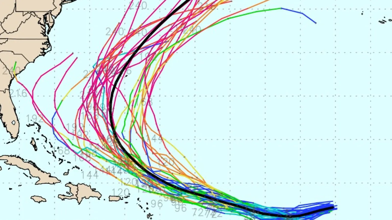
At present, Erin is more than 2,400 miles from the North Carolina coast and is tracking toward the general vicinity of the northern Caribbean Islands. Forecast models currently suggest it will pass north of Puerto Rico and the U.S. and British Virgin Islands; however, uncertainty remains over the precise trajectory it will follow later this week. Depending on shifts in steering winds, Erin could either curve toward Bermuda or take a track that brings it closer to the Southeast U.S. coastline.
Strengthening Likely in Coming Days
The National Hurricane Center reports that Erin is moving through an environment conducive to intensification. Sea surface temperatures in its path are well above the threshold for hurricane development, and wind shear is expected to remain light to moderate through Thursday. These conditions will likely lead to a steady increase in wind speed and storm organization.
By late week, meteorologists warn that Erin could experience rapid intensification, a process that may push it into Category 3 strength with sustained winds exceeding 115 mph. If that occurs, Erin would become the strongest storm so far in the 2025 Atlantic hurricane season, with the potential to maintain major hurricane status for several days.
The exact timing of the storm’s anticipated turn to the north is still uncertain. A delayed turn could allow Erin to approach closer to the continental U.S., while an earlier shift would steer it farther into the open Atlantic.
Possible Impacts Across the Region
While the United States is not currently under any warnings from Erin, parts of the northern Caribbean could begin feeling indirect effects, including increased swells, rip currents, and outer rain bands, as early as the weekend. Coastal areas of Puerto Rico and the Virgin Islands may experience rough seas even if the storm’s core remains offshore.
Bermuda also remains a potential area of concern if Erin’s path bends northward at the right point in its journey. For now, residents across the Caribbean and along the U.S. East Coast are urged to remain attentive to forecast updates, as long-range tropical projections can shift significantly in just a matter of days.
Other Tropical Systems Under Watch
While Erin commands most of the attention, meteorologists are also tracking two other areas of potential development. In the northwestern Caribbean Sea, a broad area of disturbed weather near Honduras and Nicaragua is forecast to move across the Yucatan Peninsula with only a small chance of becoming a named storm. Farther north, an area of showers and thunderstorms southeast of Nova Scotia may briefly organize as it drifts over the Gulf Stream, though it will likely weaken quickly as it enters cooler waters.
Preparedness Is Key
Even though Erin’s future path remains uncertain, forecasters emphasize that mid-August marks the heart of hurricane season, when conditions in the Atlantic are most favorable for storm formation. Coastal residents from the Caribbean to the Carolinas should use this time to review emergency plans, check disaster supply kits, and ensure they have multiple ways to receive official weather alerts.
Are you preparing for the peak of hurricane season? Share your thoughts, experiences, or preparedness tips at SaludaStandard-Sentinel.com.