Slight Risk Severe Storms Target Northern Alabama Monday With Damaging Winds and Flooding Possible From 3 PM to Midnight Before Drier Pattern Returns
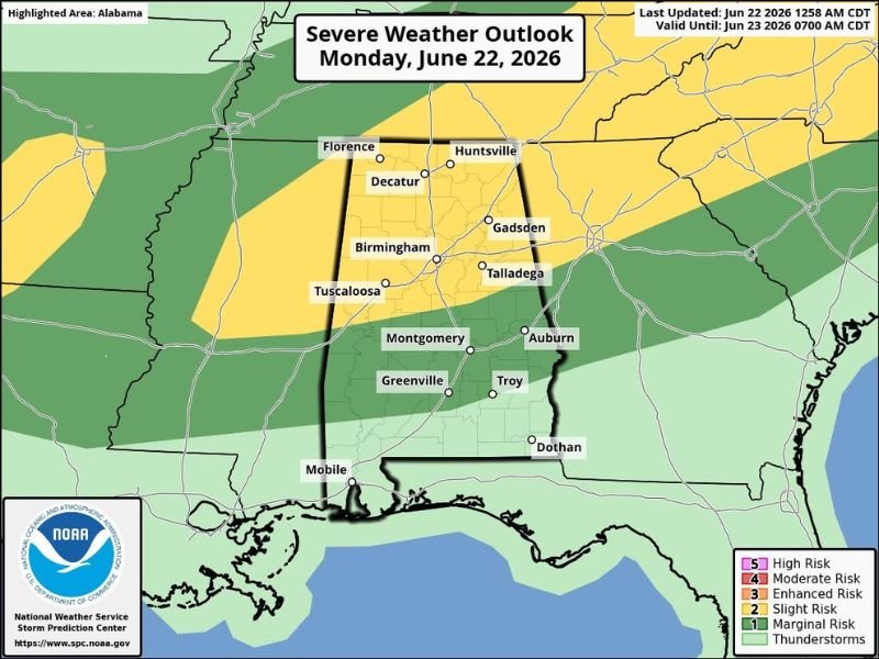
BIRMINGHAM, AL — An active weather day is underway across Alabama Monday, with the Storm Prediction Center placing the northern half of the state under a Level 2 of 5 Slight Risk for severe storms, as a line of showers and thunderstorms is expected to push southward through the state from mid-afternoon through midnight with damaging winds as the primary threat.
Storms Arrive in North Alabama This Afternoon
Early morning rain was already falling across the northwest corner of Alabama, with more widespread activity occurring to the north across western and middle Tennessee. The main severe weather window across Alabama is expected to open at 3 PM and last through midnight, with storms likely across North Alabama by mid to late afternoon before dropping southward into the central counties through the early evening hours.
Communities including Florence, Huntsville, Decatur, and Gadsden are among those in the Slight Risk zone, with Birmingham, Tuscaloosa, and Talladega also falling within the Level 2 threat area as the storm line pushes through.
Damaging Winds Are the Primary Concern
The main hazard from Monday’s storm activity will be strong to damaging winds, with the primary threat window spanning 3 PM through midnight. Forecasters noted that even sub-severe wind gusts in the 40 to 50 mph range carry elevated risk given saturated soil conditions, as weakened tree root systems may fail under wind speeds that would otherwise cause only minor damage.
A low but non-zero tornado probability exists across North Alabama, with the Storm Prediction Center defining low tornado probabilities tied to a surface boundary in the area. Forecasters emphasized this risk is very low but will be monitored closely.
Marginal Risk Extends Into Central and South Alabama
A Level 1 of 5 Marginal Risk extends as far south as Chatom, Georgiana, Troy, and Eufaula, indicating that scattered strong storms capable of producing isolated impacts remain possible well south of the primary threat zone through Monday evening.
Drier and Hotter Pattern Builds Through the Weekend
Conditions improve significantly by Tuesday, with only isolated showers expected. The remainder of the week brings typical summer weather with afternoon highs in the 85 to 90 degree range. An upper ridge building across the Deep South through the weekend will push afternoon highs into the low to mid-90s with drier conditions expected to hold through much of next week.
For continuing coverage of severe weather events and storm forecasts across the United States, visit SaludaStandard-Sentinel.com.