Father’s Day Thunderstorms Push Through Southeast Texas With Street Flooding Possible Near Houston as 1 to 3 Inches Could Fall Quickly Sunday Morning
HOUSTON, TX — Another round of thunderstorms pushed through Southeast Texas early Sunday morning on Father’s Day, bringing the threat of street flooding across the Houston metro area where forecasters warned a quick 1 to 3 inches of rain could fall, with waterspouts also possible near the Upper Texas coastline.
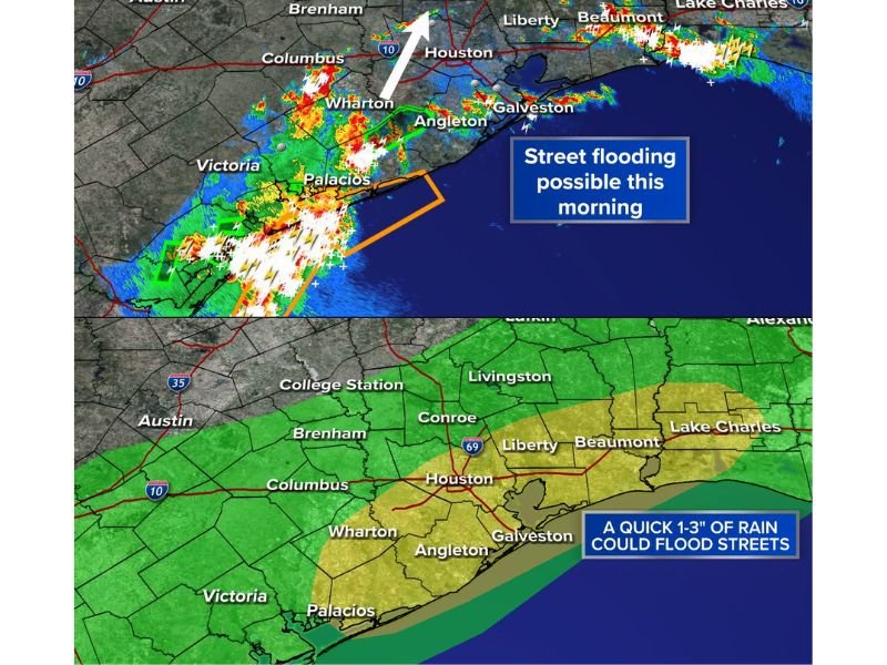
Heavy Storms Track Across the Coastal Bend
Radar imagery as of 5:14 AM Sunday showed an intense line of thunderstorms stretching from near Victoria and Palacios northeastward through Wharton and toward the Houston metro area. The storm complex contained embedded cores of very heavy rainfall, indicated by white and red radar returns, particularly across the Wharton and Angleton areas southwest of Houston.
The system continued tracking northeast, with additional heavy rain bands extending toward Beaumont and Lake Charles along the upper coast, while a separate area of storms was also developing near Conroe to the north of Houston.
Street Flooding Threat Concentrated Near Houston
Forecasters identified street flooding as the primary concern Sunday morning, with the highest rain chances and flood risk centered directly over the Houston metro area. Rain chance projections showed a 70 percent likelihood of rainfall around Houston and Angleton, with slightly lower chances near 40 percent farther north around Conroe and Brenham.
A quick 1 to 3 inches of rain falling in a short period was identified as the main trigger for potential street flooding, particularly in low-lying and poor-drainage areas across the Houston region and surrounding counties including Liberty, Galveston, and Beaumont.
Waterspouts Possible Along the Upper Coast
In addition to the street flooding threat, forecasters noted that waterspouts were also possible near the Upper Texas coastline as the storm complex moved through the Gulf-adjacent counties. Galveston and the immediate coastal waters were highlighted as an area where this secondary threat could develop alongside the heavier rain bands.
Flood Risk Extends Across Southeast Texas
The flood risk outlook for Sunday extended across a broad swath of Southeast Texas, covering Wharton, Houston, Liberty, and Beaumont, with the highest flood risk concentrated along this corridor. Residents across the region were advised to use caution on roadways as the storms continued moving through during the Father’s Day morning commute.
For continuing coverage of severe weather events and flooding impacts across the United States, visit SaludaStandard-Sentinel.com.