Flash Flood Risk Develops Overnight Across San Antonio and Laredo as Storms Intensify Through Central and South Texas Early Saturday Morning Hours
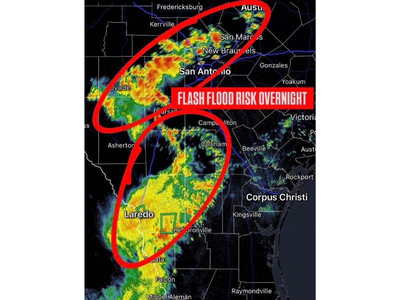
SAN ANTONIO, TX — A flash flood risk developed overnight across two distinct corridors of Central and South Texas, with thunderstorms intensifying near San Antonio and continuing southward toward Laredo, as a 12 AM CDT radar update confirmed flash flooding was likely in spots across both affected regions.
Heavy Storms Track Through the San Antonio Corridor
Radar imagery showed an organized line of storms producing heavy rainfall across the Hill Country and into the San Antonio metro area, with intense rain cores indicated by red and orange returns extending from near Uvalde eastward through San Antonio and toward New Braunfels and San Marcos. Isolated stronger cells were also visible pushing into the Austin area along the northern edge of this corridor.
The concentration of repeated heavy rainfall over this stretch of Central Texas raised concerns for rapid runoff and localized flash flooding, particularly in low-lying areas and around area waterways prone to quick rises.
A Second Flash Flood Zone Stretches Toward Laredo
A separate area of heavy rain was tracking through South Texas, with storms producing significant rainfall rates near Callihan, Hebbronville, and Laredo. This southern corridor showed an extensive area of yellow and orange radar returns, indicating sustained moderate to heavy rainfall continuing across the region overnight.
The combination of two active flash flood corridors moving through Central and South Texas simultaneously created an elevated overnight risk for residents across a broad stretch of the state, from the Hill Country down to the Mexican border region.
Storms Expected to Persist Through Early Morning Hours
Both areas of heavy rainfall were continuing to develop and intensify as of the midnight update, suggesting the flash flood risk would likely persist into the early morning hours before any meaningful improvement. The slow movement of storm cells over the same areas increased the likelihood of training, a pattern in which repeated rounds of rain fall over identical locations.
Residents Urged to Use Caution Overnight
With flash flooding considered likely across both the San Antonio and Laredo corridors, residents in affected areas were urged to avoid driving through flooded roadways and to remain alert to changing conditions throughout the overnight hours, particularly given the reduced visibility that comes with flooding after dark.
For continuing coverage of flooding threats and severe weather impacts across the United States, visit SaludaStandard-Sentinel.com.