Showers and Thunderstorms Set to Develop Late Tonight Near San Antonio With Heaviest Activity Expected Between 11 PM and 2 AM Saturday Morning Across South Texas
SAN ANTONIO, TX — Forecast radar guidance shows showers and thunderstorms gradually developing across South Texas late Friday night, with activity expected to become noticeably more active between 11 PM and 2 AM Saturday as a corridor of heavier rain pushes through the San Antonio metro area and surrounding communities.
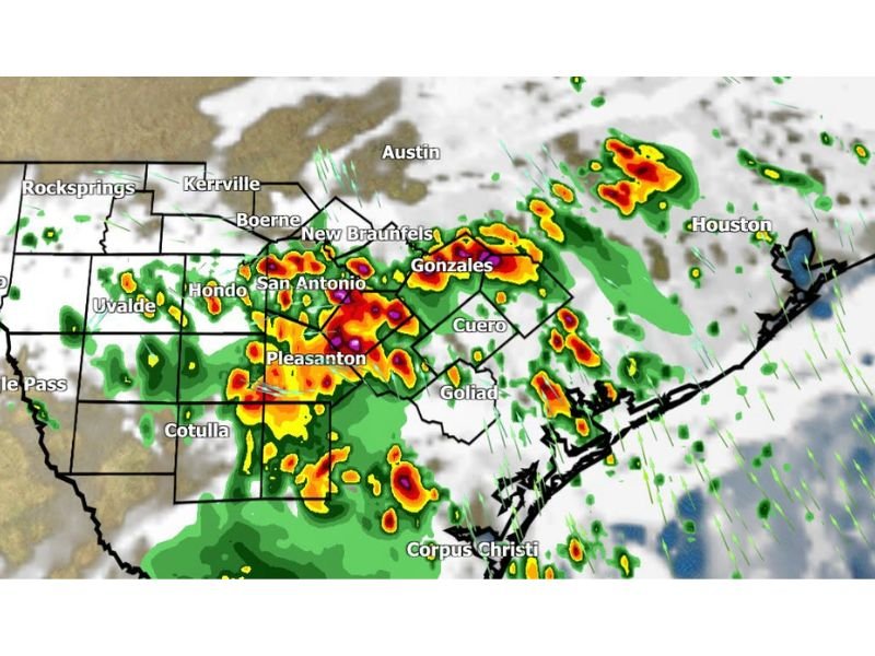
Storms Intensify Overnight Around San Antonio
Future radar projections for 2 AM Saturday show a significant area of heavy rainfall centered directly over San Antonio, with embedded cores of intense precipitation indicated by red, orange, and purple returns. This concentrated area of heavier storms is expected to develop gradually through the late evening hours before peaking in intensity around the overnight timeframe.
Communities surrounding San Antonio, including Hondo, Pleasanton, and Cotulla, are also expected to see heavier rain bands move through as the activity expands and organizes through the night.
Hill Country and I-35 Corridor Also Affected
Areas to the north and east of San Antonio, including Boerne, New Braunfels, and Gonzales, are forecast to see scattered to numerous showers and thunderstorms develop as the overnight activity spreads across the Interstate 35 corridor. Cuero and Goliad are also expected to see rain chances increase as the system moves through the broader region.
Farther west, areas including Uvalde, Hondo, and Eagle Pass are expected to see lighter, more scattered activity, with the most organized and heaviest rainfall remaining focused closer to the San Antonio metro area itself.
Activity Expected to Build Steadily Through the Night
Forecasters note that radar activity is expected to gradually increase between 11 PM and 2 AM as showers and thunderstorms develop and consolidate across the region. This timeframe represents the window when residents across South Texas are most likely to experience heavier rainfall, lightning, and gusty winds associated with the developing storm cells.
Coastal Areas See Lighter Rain Chances
Areas closer to the coast, including Corpus Christi, are expected to see comparatively lighter and more scattered shower activity overnight compared to the more concentrated storm development occurring farther inland near San Antonio and the surrounding Hill Country communities.
For continuing coverage of overnight forecasts and storm development across the United States, visit SaludaStandard-Sentinel.com.