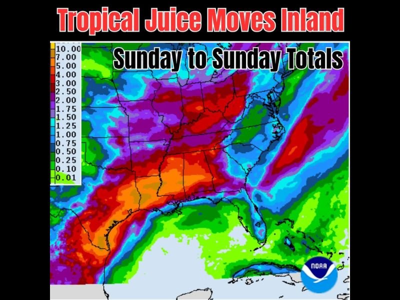
Tropical Moisture Pulled Into Texas Fuels Rainfall Totals Up to 10 Inches Across the Ohio Valley This Week With Isolated Flooding Likely Through Next Sunday
LOUISVILLE, KY — A significant tropical moisture surge is being pulled into Texas and pushed eastward by an approaching and lingering frontal boundary, setting the stage for substantial rainfall totals across a wide swath of the central and eastern United States over the next seven days, with isolated flooding likely in the heaviest impact zones spanning from Texas through the Ohio Valley.
Where the Heaviest Rain Falls
NOAA seven-day rainfall accumulation data covering Sunday to Sunday shows an expansive corridor of extreme totals stretching from eastern Texas and Louisiana northeastward through Arkansas, Tennessee, Kentucky, and into the Ohio Valley region. The deepest purple and red shading on the map — representing totals in the 5 to 10 inch range — covers a broad area centered on the lower Mississippi Valley and extending through Kentucky and southern Ohio.
Eastern Texas and Louisiana show particularly intense totals approaching 7 to 10 inches in localized pockets, reflecting the direct injection of tropical moisture into the region as the system pulls Gulf moisture northward and eastward.
The Tropical Juice Mechanism
The driving factor behind this rainfall event is tropical moisture being drawn into Texas from the Gulf and subsequently transported eastward by an approaching front that is expected to linger across the region for an extended period. This combination of a persistent frontal boundary and a continuous tropical moisture feed is the recipe for the multi-day, high-accumulation rainfall pattern depicted on the seven-day total map.
A secondary band of elevated totals in the 2.5 to 5 inch range extends along the Atlantic Seaboard from the Carolinas through the Northeast, indicating a separate area of concern along the East Coast during the same period.
Flooding Concerns
With totals reaching 5 to 10 inches across portions of the lower Mississippi Valley and Ohio Valley over a seven-day period, isolated flooding is a significant concern for low-lying areas, river corridors, and locations with poor drainage. Repeated rounds of heavy rainfall over the same general areas increase the likelihood of rapid water rises in streams and creeks throughout the affected region.
Residents across Texas, Louisiana, Arkansas, Tennessee, Kentucky, and Ohio should monitor National Weather Service flood guidance closely throughout the week. For continuing coverage of rainfall and flooding threats across the United States, visit SaludaStandard-Sentinel.com.