Gulf of Mexico Disturbance Threatens Heavy Rain and Flooding Along the Texas and Louisiana Coast Next Week With Tropical Depression Development Possible
NEW ORLEANS, LA — A tropical disturbance firing disorganized showers and storms across the southwestern Gulf of Mexico is being closely monitored Saturday, June 13, as it tracks toward a Mexico landfall Sunday before potentially re-emerging off the Texas and Louisiana coastline early next week — bringing a heavy rain and flooding threat to the northern Gulf Coast regardless of whether it achieves tropical depression status during re-emergence.
Current Disturbance Status
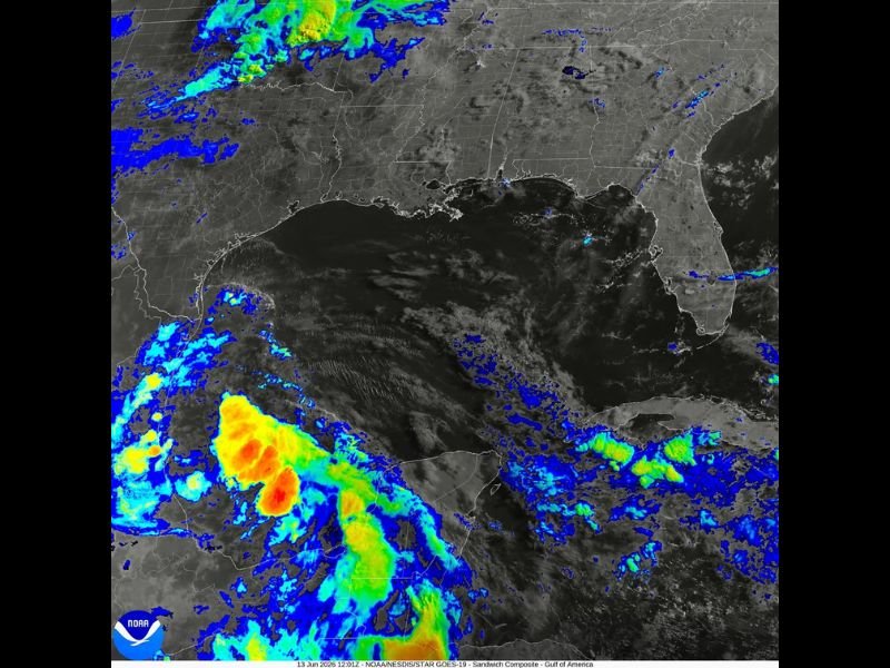
NOAA GOES-19 satellite imagery captured at 12:01Z June 13 shows the southwestern Gulf disturbance producing a disorganized but active convective signature, with intense red and orange satellite returns concentrated along the Mexican coastline and a broader shield of tropical moisture extending across the southwestern Gulf basin. A slight spin on satellite imagery confirms low-level circulation is present, though the system lacks the organization required for formal tropical classification at this time.
Forecasters assess the disturbance as unlikely to develop sufficiently before making landfall along the Mexican coast Sunday, given the limited time remaining over water for organization to occur.
The Re-Emergence Threat
The more significant concern for the United States develops after the system crosses Mexico and re-emerges into the Gulf of Mexico off the Texas and Louisiana coastline early next week. At that point, a window exists for the disturbance to consolidate into a tropical depression as it encounters warm Gulf waters and a more favorable atmospheric environment for development.
The first name on the 2026 Atlantic tropical storm list is Arthur, meaning any system reaching tropical storm strength would receive that designation upon classification.
Heavy Rain and Flood Threat Regardless of Development
Whether or not the system achieves tropical depression or tropical storm status upon re-emergence, the northern Gulf Coast from Texas through Louisiana faces a meaningful heavy rain and flooding threat early next week. Tropical moisture streaming northward from the Gulf will combine with existing frontal boundaries to produce multi-inch rainfall totals across the affected coastal zone.
Flash flooding is a primary concern for low-lying coastal communities and areas with already saturated soils from recent rainfall events across the region.
Residents along the Texas and Louisiana Gulf Coast should monitor National Hurricane Center updates closely through the weekend and into next week as this system’s evolution becomes clearer.
For continuing coverage of Gulf Coast tropical threats and severe weather across the United States, visit SaludaStandard-Sentinel.com.