Weakening Storm Complex Tracking Toward Tulsa and Broken Arrow Early Saturday With 100 Lightning Strikes Recorded Across Central Oklahoma
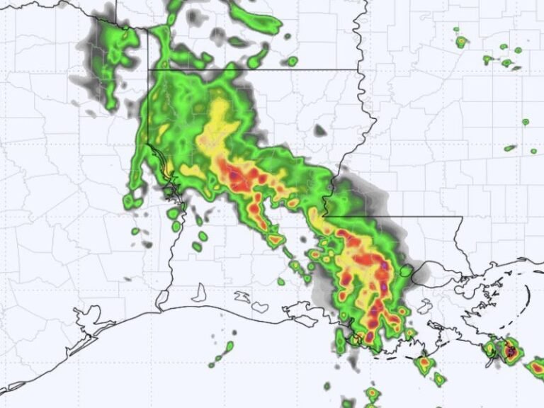
TULSA, OK — A storm complex tracking eastward across central Oklahoma at 5:17 a.m. Saturday, June 13, was confirmed to be below severe limits and continuing to weaken as it pushed toward Tulsa and Broken Arrow, with VIPIR 3D reflectivity radar showing active but diminishing cores near Pawnee, Hominy, Glencoe, and Stillwater and a total lightning strike count of 100 recorded across the broader storm area.
Radar Conditions at 5:17 AM
VIPIR 3D reflectivity data captured at 5:17 a.m. Saturday showed a cluster of storm cells with yellow, orange, and red cores concentrated across the Pawnee, Hominy, Ralston, and Glencoe corridor in central Oklahoma. The storm complex was moving due east along and near Highway 412, placing Sperry, Mannford, and the northern Tulsa metro in the path of the weakening system as it continued its eastward progression.
Black arrows on the radar graphic indicated the storm’s eastward track, with the leading edge approaching the Tulsa and Broken Arrow metropolitan area at the time of the scan. Despite the radar presentation showing reflectivity values that appear intense visually, meteorologists confirmed the complex had fallen below the thresholds required for severe weather classification and was trending toward further weakening.
Lightning the Primary Remaining Hazard
With the storm complex below severe limits, the most significant remaining hazard for communities in its path was frequent lightning. A total of 100 cloud-to-ground lightning strikes were recorded across the storm area at the time of the 5:17 a.m. snapshot, indicating that while wind and hail threats had diminished, electrical activity remained active and dangerous for anyone outdoors in the affected corridor.
Lightning remains a life-threatening hazard even from weakening storms — a single strike can be fatal regardless of overall storm intensity, making outdoor avoidance essential until the complex fully clears the area.
Communities in the Eastward Track
Tulsa, Broken Arrow, Glenpool, and Coweta sat directly in the storm’s projected eastward track as the complex continued moving away from its more intense initiation zone near Stillwater and Cushing. Communities along the Highway 44 corridor including Stroud and Bristow also fell within the broader path of the weakening system through the early morning hours.
Residents across the Tulsa metro who were awakened by thunder were advised that conditions were safe to return to sleep as the non-severe complex moved through.
For continuing coverage of Oklahoma weather and storm activity across the United States, visit SaludaStandard-Sentinel.com.