Prolonged Heat Gripping Birmingham Alabama Through Friday With Highs Reaching 93 Degrees Before Weekend Storm Chances Increase and Strong Storms Return Monday and Tuesday
BIRMINGHAM, AL — A prolonged stretch of hot and humid weather is firmly established across Birmingham and central Alabama through Friday, June 13, with daily highs ranging from 91 to 93°F and high humidity keeping conditions oppressive before a gradual pattern shift brings increased storm chances over the weekend and a more active severe weather round targeting the state Monday and Tuesday of next week.
Midweek Heat Through Friday
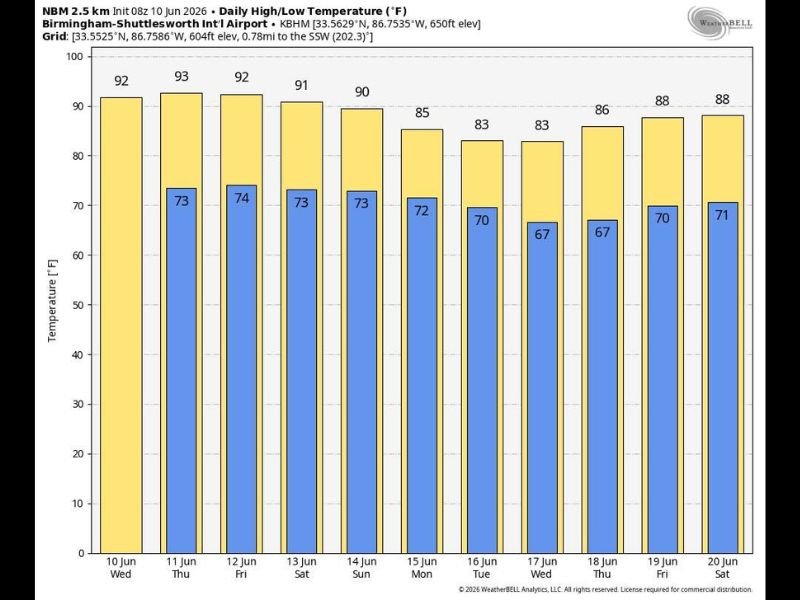
NBM 2.5 km forecast data for Birmingham-Shuttlesworth International Airport shows Wednesday opening at 92°F before Thursday peaks at 93°F — the hottest day of the current stretch. Friday eases slightly to 92°F and Saturday drops to 91°F as the upper ridge begins a gradual weakening trend. Overnight lows through the period hold in the low 70s, with Wednesday and Thursday nights staying at 73 to 74°F — providing minimal overnight recovery from the daytime heat load.
Humidity levels will remain high through the entire midweek period, with heat index values pushing well above the actual air temperatures during peak afternoon hours. Isolated afternoon and evening showers are possible through Friday but most locations will remain rain-free under the ridge’s suppressing influence.
Weekend Transition
As the upper ridge weakens heading into the weekend, atmospheric instability increases gradually across the region. Saturday holds at 90°F with Sunday dropping to 85°F as cloud cover increases and scattered showers and thunderstorms become more likely. The best rain chances both days will fall in the noon to midnight window, though the weekend will not be a washout with sunshine expected at times between storm chances.
Active Pattern Returns Next Week
The most significant weather shift arrives Monday and Tuesday, June 16 and 17, as an upper trough and approaching frontal boundary combine to bring numerous showers and storms to Alabama. A few strong storms will be possible during this period, with some locations potentially seeing heavy rainfall totals across both days. Highs ease to the low 80s Monday through Wednesday before recovering toward the mid to upper 80s by the following weekend.
Overnight lows drop noticeably into the upper 60s mid-next week, offering the most comfortable sleeping conditions of the entire forecast period. For continuing coverage of Alabama heat and storm threats across the United States, visit SaludaStandard-Sentinel.com.