Muggy and Humid Saturday Brings Upper 80s and Heat Index Near 90 Degrees With Morning Storms Ending Early and Afternoon Redevelopment Possible June 6
CLEVELAND, OH — A noticeably muggy and uncomfortable Saturday is underway across the region as elevated humidity levels that became apparent in a significant way on Friday continue building through the weekend, with temperatures climbing from 68 degrees at 6 AM through the upper 80s by late afternoon while heat index values approach and potentially exceed 90 degrees even as lingering morning showers give way to a generally drier but still unsettled afternoon pattern.
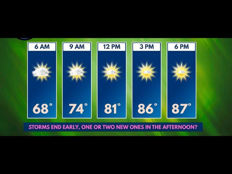
Hourly Breakdown Shows Rapid Afternoon Warmup
The Saturday June 6 hourly forecast progression tells the story of a day that starts cloudy and unsettled before transitioning into a warm and oppressively humid afternoon with partial sunshine and isolated storm potential.
Temperatures begin the morning at 68 degrees at 6 AM under partly cloudy skies with lingering shower activity possible, climbing to 74 degrees by 9 AM as cloud cover begins breaking and early morning storm activity winds down across the region. The noon hour brings 81 degrees with mostly sunny skies taking hold across most areas, before the afternoon surge pushes temperatures to 86 degrees by 3 PM and 87 degrees by 6 PM under partly sunny skies as the day’s heating peaks during the early evening hours.
Humidity Is the Real Story Saturday
While the temperature readings of upper 80s are warm but not extreme for early June, the elevated humidity blanketing the region transforms the feel of the day into something considerably more oppressive and physically demanding for anyone spending extended time outdoors during the afternoon hours.
Humidity levels on Saturday are running on the higher side without yet reaching the truly unbearable category, but are sufficient to drive heat index values to approximately 90 degrees or slightly above during the peak afternoon heating period, meaning the body will experience conditions equivalent to 90 degree temperatures even when the actual thermometer reads in the mid to upper 80s.
Morning Storms Clear but Afternoon Redevelopment Possible
Lingering showers and isolated storms are a viable possibility through the noon hour as the overnight and early morning storm activity slowly exits the region, with the general expectation that conditions will dry out during the afternoon hours as the morning storm energy dissipates and the atmosphere stabilizes temporarily.
However forecasters cannot entirely rule out one or two new storm cells developing during the afternoon hours along any boundaries or areas of enhanced surface convergence that develop during the peak heating period, making it advisable for anyone with extended outdoor afternoon plans to keep a close eye on radar through the Saturday evening hours.
For continuing coverage of weekend weather forecasts and heat index alerts across the United States, visit SaludaStandard-Sentinel.com.