Houston Texas Roads Literally Created Clouds Visible From Space in a Rare Urban Heat Island Phenomenon That Has Meteorologists Talking Across the Country
HOUSTON, TX — A remarkably rare and visually stunning atmospheric phenomenon was captured over Houston, Texas in early morning satellite imagery showing clouds forming directly and precisely above the city’s freeway and road network in perfect alignment with the street grid, creating a ghostly aerial outline of the entire Houston highway system visible from space and drawing widespread attention from meteorologists across the country who describe it as something very few people have ever witnessed.
Roads Literally Generating Their Own Clouds
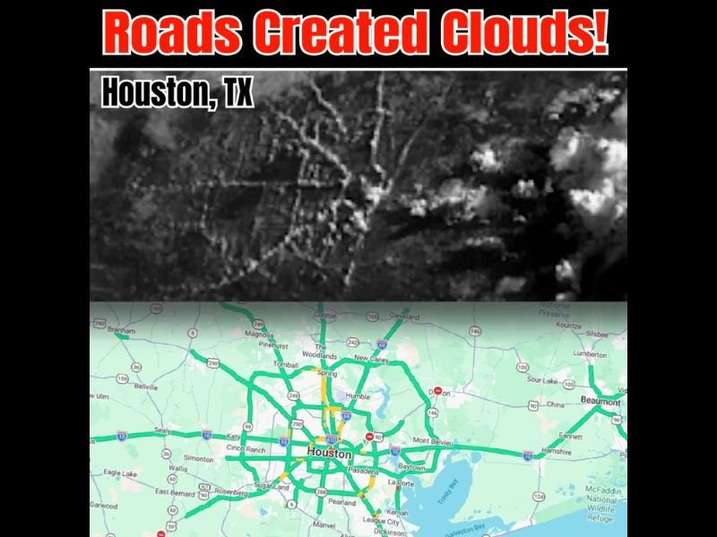
Satellite imagery captured during the early morning hours shows a striking black and white cloud formation pattern over the Houston metropolitan area where the city’s major roadways including Interstate 10, Interstate 45, Interstate 69, Interstate 610, and the broader freeway network are traced in cloud cover with remarkable precision, creating a formation so perfectly aligned with the street grid below that it mirrors the road map of the city almost exactly.
The side by side comparison between the satellite cloud imagery and a Houston road map confirms beyond doubt that the cloud formation is directly following the city’s freeway network, with the densest cloud development appearing precisely above the highest traffic volume corridors running through the heart of the metropolitan area.
The Science Behind This Extraordinary Event
The explanation for this rare phenomenon lies in the intersection of Houston’s extreme humidity, warm overnight temperatures, and the unique heat retention properties of concrete and asphalt road surfaces.
Humid and warm conditions caused the city’s roads to heat up faster than the surrounding vegetated and less developed areas during the early morning hours, creating localized zones of enhanced surface heating directly above the roadway corridors. Light wind conditions at the time of the event were insufficient to disperse the rising warm and moist air, allowing it to lift, cool, and condense into visible cloud formation precisely above the roads that generated the extra heat.
Traffic moving along the freeway network during the early morning commute hours likely contributed additional heat energy through vehicle exhaust and engine output, reinforcing the thermal differential between the road corridors and surrounding areas and helping sustain the cloud formation long enough to be captured in satellite imagery.
Why Meteorologists Are Paying Attention
The Houston freeway cloud event is drawing significant discussion within the meteorological community because it provides a visually dramatic and unusually clear demonstration of the urban heat island effect, a well-documented phenomenon where cities generate measurably higher temperatures than surrounding rural areas due to the heat-absorbing properties of built infrastructure.
Most urban heat island demonstrations rely on temperature data and maps to make the effect visible to the public. The Houston freeway clouds achieved something far more powerful by making the phenomenon literally visible from space in a form that requires no scientific training to understand and appreciate.
For continuing coverage of rare atmospheric phenomena and Houston weather developments across the United States, visit SaludaStandard-Sentinel.com.