Tornado Warning Issued for Southeast Kansas Near Erie as Tornado Capable Thunderstorm Moves East at 20 MPH Threatening Chanute and St Paul Communities
ERIE, KS — A tornado warning was issued for southeastern Kansas after a severe thunderstorm capable of producing a tornado was located near Erie, moving eastward at 20 miles per hour and placing multiple Neosho and Woodson County communities under an immediate take shelter directive as radar depicted an extremely intense and well-organized storm core with alarming reflectivity values across the warned area.
Radar Presentation Signals Extreme Danger
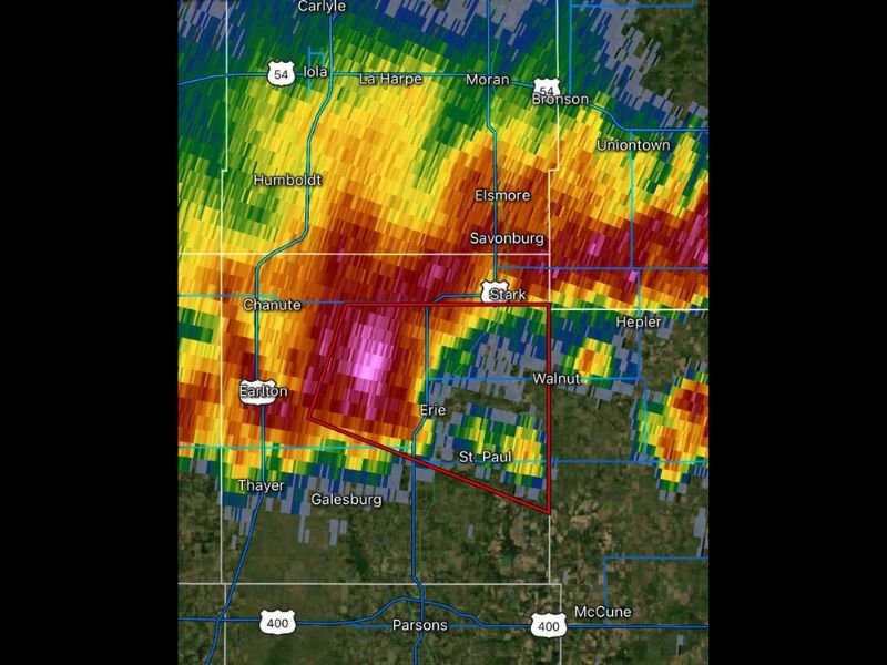
Radar imagery at the time of the warning shows one of the most intense storm core presentations possible, with deep magenta and pink reflectivity values concentrated directly over the Erie and Earlton area within the active tornado warning polygon, indicating an exceptionally powerful and organized storm system carrying the atmospheric characteristics associated with tornado production.
The warning polygon encompasses a focused corridor stretching from near Chanute and Earlton eastward through Erie, Stark, Walnut, and St. Paul, with the most dangerous storm core positioned squarely over the Erie community at the time of the warning issuance and tracking steadily eastward at 20 miles per hour toward additional communities within the polygon boundaries.
Communities in the Direct Threat Zone
The tornado warning polygon as drawn on radar places several southeastern Kansas communities in the direct path of the warned storm, with Erie sitting at the center of the most intense radar returns and St. Paul positioned directly in the storm’s projected eastward track during the valid warning period.
Surrounding communities including Chanute, Earlton, Stark, Walnut, Galesburg, and areas along US Route 400 near Parsons and McCune also fall within or immediately adjacent to the warned zone, requiring all residents across this portion of southeastern Kansas to treat the warning with the utmost seriousness and take immediate protective action.
Immediate Shelter Required
All residents within the tornado warning polygon were directed to move to the lowest floor of a sturdy structure immediately, placing themselves in an interior room away from all windows and exterior walls until the warning expires or is canceled by the National Weather Service.
Anyone outdoors, in a vehicle, or in a mobile home within or near the warned area was urged to abandon that exposure immediately and seek the most substantial permanent shelter available before the storm arrives in their location.
Regional Severe Weather Context
The tornado warning near Erie is part of a broader and active severe weather pattern impacting southeastern Kansas during this period, with multiple intense storm cells producing dangerous conditions across the region as the atmospheric setup supports organized and potentially tornadic thunderstorm development across the central plains.
For continuing coverage of tornado warnings and severe weather emergencies across the United States, visit SaludaStandard-Sentinel.com.