Massive Shelf Cloud Rolls Through Bolivar Missouri Delivering a Stunning and Ominous Wall of Storm Structure Across the Ozarks Region
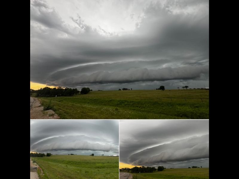
BOLIVAR, MO — A massive and visually spectacular shelf cloud rolled through Bolivar, Missouri delivering one of the most dramatic storm structure presentations seen across the Ozarks region, with stunning photography capturing the enormous arcus cloud formation stretching across the entire horizon as it pushed through the Polk County landscape against a backdrop of golden sunset light on the western horizon.
A Textbook and Enormous Shelf Cloud
Multiple photographs captured from the Bolivar area show a remarkably well-defined and expansive shelf cloud formation displaying the classic layered and rolling appearance that characterizes the most photogenic and powerful examples of this storm structure type across the central United States plains and Ozarks region.
The leading edge of the shelf cloud presents a sharp, smooth, and dramatically curved boundary at its base, with turbulent and layered cloud structure rolling upward and backward into the storm’s interior above, reflecting the intense inflow of warm surface air being rapidly lifted along the storm’s gust front as the system sweeps through the Bolivar area.
What a Shelf Cloud Signals
A shelf cloud of this size and definition is a direct visual indicator of a powerful outflow boundary pushing outward ahead of an organized and intense thunderstorm or squall line system, marking the precise location where cold downdraft air from within the storm collides forcefully with the warm and unstable surface air ahead of it.
The dramatic visual appearance of a large shelf cloud is accompanied by rapidly deteriorating surface conditions including sharply dropping temperatures, sudden and strong wind gusts, and the imminent arrival of heavy rainfall as the storm’s precipitation core follows closely behind the leading gust front boundary.
Bolivar and Polk County in the Storm’s Path
Bolivar sits in Polk County in the heart of the Missouri Ozarks, a region that experiences a full range of severe weather activity during the spring and early summer months as Gulf moisture streams northward and interacts with atmospheric instability and wind shear across the central Missouri landscape.
The scale and organization of the shelf cloud documented in these photographs indicates a well-organized and substantial storm system pushing through the region, one carrying the potential for damaging outflow winds, heavy rainfall, and frequent lightning across communities throughout the Bolivar area and surrounding Polk County.
Nature’s Most Dramatic Storm Photography
Shelf clouds consistently rank among the most visually striking and widely photographed weather phenomena across the central United States, combining genuine meteorological significance with an aesthetic power that captures the raw scale and energy of the thunderstorm systems that define spring and summer weather across Missouri and the broader Ozarks landscape.
For continuing coverage of severe weather events and storm photography across the United States, visit SaludaStandard-Sentinel.com.