Rare Severe Thunderstorm Watch Issued for All of Eastern Washington Ending a 1102 Day Streak With 75 MPH Gusts and Golf Ball Size Hail Possible Through Midnight
SPOKANE, WA — NOAA’s Storm Prediction Center has issued a Severe Thunderstorm Watch covering all of Eastern Washington from the Cascade crest to the Idaho border and from Canada to Oregon, ending a remarkable 1,102 day streak without such a watch across the Spokane National Weather Service coverage area, ranking as the seventh longest such streak in the United States at the time of issuance.
What the Watch Means and How Rare It Is
The Severe Thunderstorm Watch, valid until midnight Friday morning, signals that atmospheric conditions are ripe for thunderstorms capable of producing wind gusts up to 75 miles per hour and hail up to 1.5 inches in diameter, roughly the size of a ping pong ball, across the entire Eastern Washington region and extending into much of eastern Oregon, northern Idaho, and western Montana.
The 1,102 day drought without a Severe Thunderstorm Watch across this territory represents just over three years, a streak that only five National Weather Service offices across California, western Nevada, and Key West, Florida surpassed at the time this watch was issued.
Storm Movement and Timing
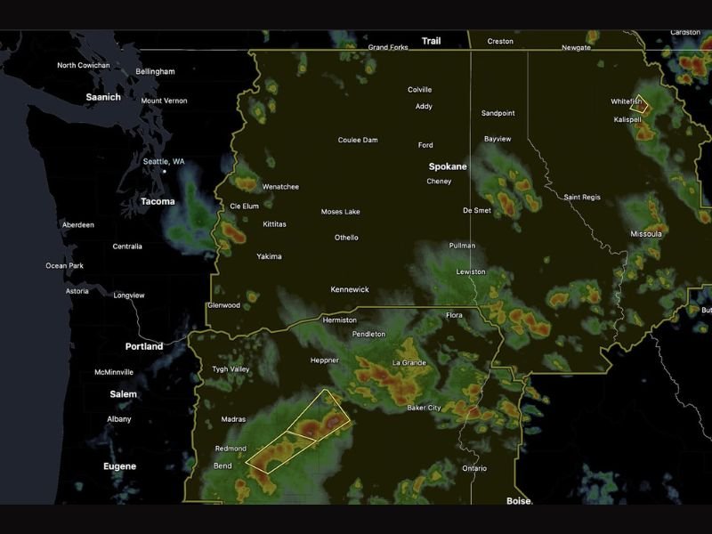
Unlike typical Pacific Northwest weather systems that approach from the west, this event will arrive from an unusual direction as a batch of organized strong thunderstorms pushes into southeastern Washington near Pullman around 7 PM before tracking from southeast to northwest across Eastern and Central Washington through Thursday evening and into Thursday night.
The unconventional storm movement is driven by a broad area of low pressure centered over Nevada spinning the storm activity northward into the Inland Northwest, creating a track that residents unaccustomed to seeing storms arrive from the southeast should note carefully when monitoring radar.
Primary Threats and Safety Guidance
Frequent lightning, heavy rain, large hail, and powerful wind bursts represent the primary hazards as the line sweeps through the region during the evening hours. Radar imagery shows storm activity already firing across portions of the watch area, with intense cores visible near the Oregon border and across the De Smet and Pullman corridors.
Anyone with outdoor plans Thursday evening across Eastern Washington, eastern Oregon, northern Idaho, or western Montana is strongly urged to monitor radar closely, move indoors well before the line arrives, and remain sheltered until conditions calm considerably after the line passage.
Western Washington Outlook
Western Washington including the Seattle and Tacoma areas faces minimal threat from this event, with the Eastern Washington storm line expected to weaken before reaching the Cascades. Localized pop-up showers near the Olympic Mountains and southern Kitsap Peninsula remain possible Thursday evening before spotty rain develops along and east of Interstate 5 into Friday morning.
For continuing coverage of severe weather watches and Pacific Northwest storm events across the United States, visit SaludaStandard-Sentinel.com.