Florida Hurricane Hype Debunked as GFS Model Drops Storm Completely in 24 Hours While European Model Shows Nothing for Early June 2026
MIAMI, FL — Widespread social media alarm over a potential hurricane threatening Florida during early June 2026 is being firmly walked back by meteorologists after the American GFS model that sparked the online panic completely dropped the system from its forecast within just 24 hours, while the European model never indicated any tropical development for the same period in the first place.
What the Models Actually Show
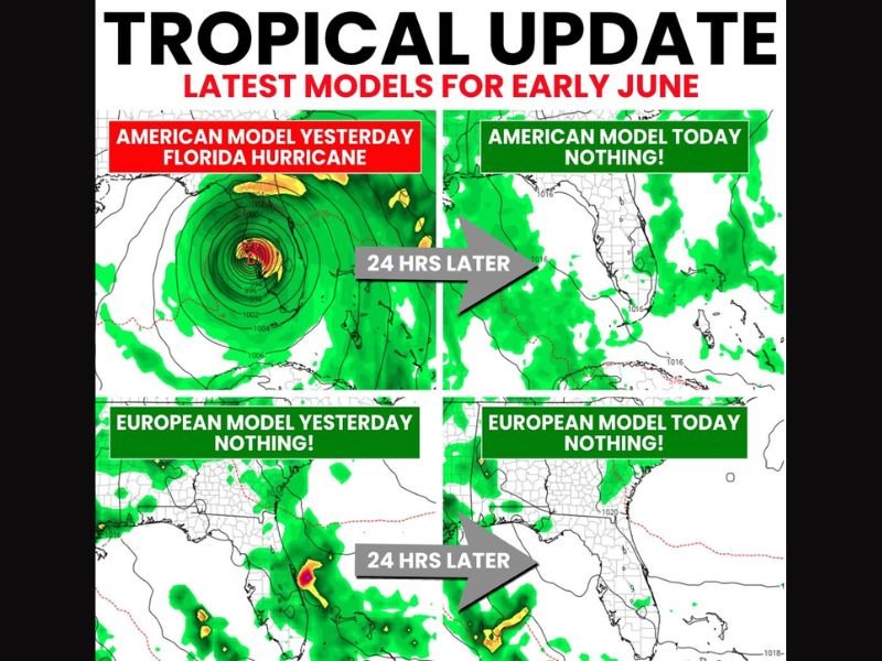
Side by side model comparison imagery tells a clear and decisive story about the credibility of the viral Florida hurricane threat circulating across social media platforms in recent days.
The GFS model showed a well-defined hurricane signature near Florida in one forecast run, then showed absolutely nothing for the identical time period just 24 hours later, a dramatic flip that highlights precisely why a single worst-case model run should never be treated as a reliable forecast. The European model, widely regarded as carrying equal or greater skill than the GFS at extended ranges, showed no tropical development whatsoever on both days of comparison.
GFS Known for Spinning Up Ghost Systems
The GFS model carries a well-documented and long-standing tendency to generate phantom tropical systems in early season runs that never materialize into actual storm development, a behavior that has been observed repeatedly across multiple hurricane seasons including notably poor GFS tropical performance in 2025.
When model ensemble members and multiple independent modeling systems fail to consistently agree on a tropical development scenario, forecasters treat the signal as unreliable noise rather than a legitimate threat worth communicating to the public.
Tropical Moisture Still Worth Watching
While no credible hurricane threat exists for Florida in early June at this time, tropical moisture tracking northward will contribute to elevated rain chances across portions of the Gulf Coast including Florida over the next ten days.
This moisture-driven rainfall increase represents a legitimate and expected early season pattern that residents can prepare for without alarm, representing a meaningfully different scenario from the catastrophic hurricane imagery that circulated widely across online platforms.
Avoid Worst-Case Scenario Hype
Meteorologists are urging Gulf Coast and Florida residents to resist the temptation to share or react to single-model worst-case forecast outputs, particularly during the early portion of hurricane season when atmospheric predictability at extended ranges is inherently limited.
The National Hurricane Center remains the authoritative source for all tropical weather information, and no watches, warnings, or advisories have been issued for any developing system threatening Florida during the early June timeframe. For continuing coverage of tropical weather updates and hurricane season developments across the United States, visit SaludaStandard-Sentinel.com.