Tornado Warning Issued for Eastern Kentucky Near Blaine as Tornado Capable Severe Thunderstorm Moves East at 15 MPH Threatening Paintsville Area Communities
BLAINE, KY — A tornado warning was issued for eastern Kentucky after a severe thunderstorm capable of producing a tornado was located over Mima, approximately 11 miles southwest of Blaine, with the dangerous storm system tracking eastward at 15 miles per hour and placing multiple communities under an immediate take shelter directive.
Storm Location and Movement
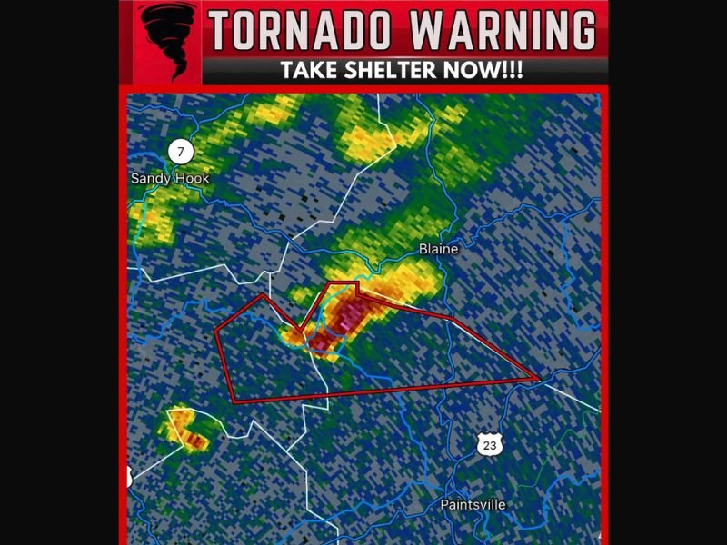
The warned storm was positioned over the Mima area at the time of issuance, with radar imagery showing a concentrated area of intense reflectivity values indicating a well-organized and dangerous thunderstorm core capable of producing a tornado on the ground.
The storm’s eastward track at 15 miles per hour places communities along and near its projected path in the direct threat zone, with the warning polygon on radar encompassing a significant portion of the surrounding eastern Kentucky landscape including areas in the vicinity of Blaine and extending toward communities to the east and southeast.
Immediate Shelter Directive in Effect
Residents within the warned area were directed to take shelter immediately upon issuance of the tornado warning, moving to the lowest floor of a sturdy structure, away from windows, and into an interior room to maximize protection against potential tornado impacts.
The warning represents one of the most serious alerts issued by the National Weather Service and indicates that forecasters identified either a confirmed tornado or radar signatures strongly suggesting imminent tornado development within the warned area.
Communities in the Threat Zone
Radar polygon boundaries at the time of the warning encompassed communities in the broader region between Sandy Hook to the northwest and Paintsville to the southeast along the US Route 23 corridor.
The positioning of the storm and its eastward movement indicated that Blaine and surrounding Lawrence County communities faced the most immediate threat, with the warning area extending to capture additional communities that fell within the projected storm path during the valid warning timeframe.
Safety Actions for Residents
Anyone caught outdoors or in a vehicle within or near the warned area was strongly urged to abandon that exposure immediately and seek substantial shelter without delay.
Mobile homes and temporary structures offer no adequate protection from tornado winds, and residents in such structures within the warning zone were advised to relocate to a nearby permanent building before the storm arrived. For continuing coverage of severe weather emergencies and tornado warnings across the United States, visit SaludaStandard-Sentinel.com.